Castle Mountains National Monument
Designation: National Monument
Location: California
📘 Park Overview
Castle Mountains represents some of the most unique elements of the Mojave Desert. Nestled between the Nevada state line and Mojave National Preserve, the nearly 21,000 acres of Castle Mountains boasts Joshua tree forests, unbroken natural landscapes, rare desert grasslands, and rich human history. This intriguing area provides serenity and solitude from nearby metropolitan areas.
🌤 Weather Information
Weather at Castle Mountains changes with the seasons. Freezing temperatures are expected in winter, with occasional snow. Spring brings mild warm days and cooler nights. With enough rain, wildflowers can carpet the area, making for spectacular displays. Summer months are much hotter, with temperatures nearing 100 degrees Fahrenheit. Strong monsoonal storms in late summer may cause flash-flooding in low-lying areas and can create hazardous road conditions. Fall is a cooler respite after the heat of summer.
🚗 Directions
You can approach Castle Mountains from Walking Box Ranch Road off of Nevada State Rd 164 (Nipton Road) or from several unnamed dirt roads off of Lanfair Road in Mojave National Preserve.
Images
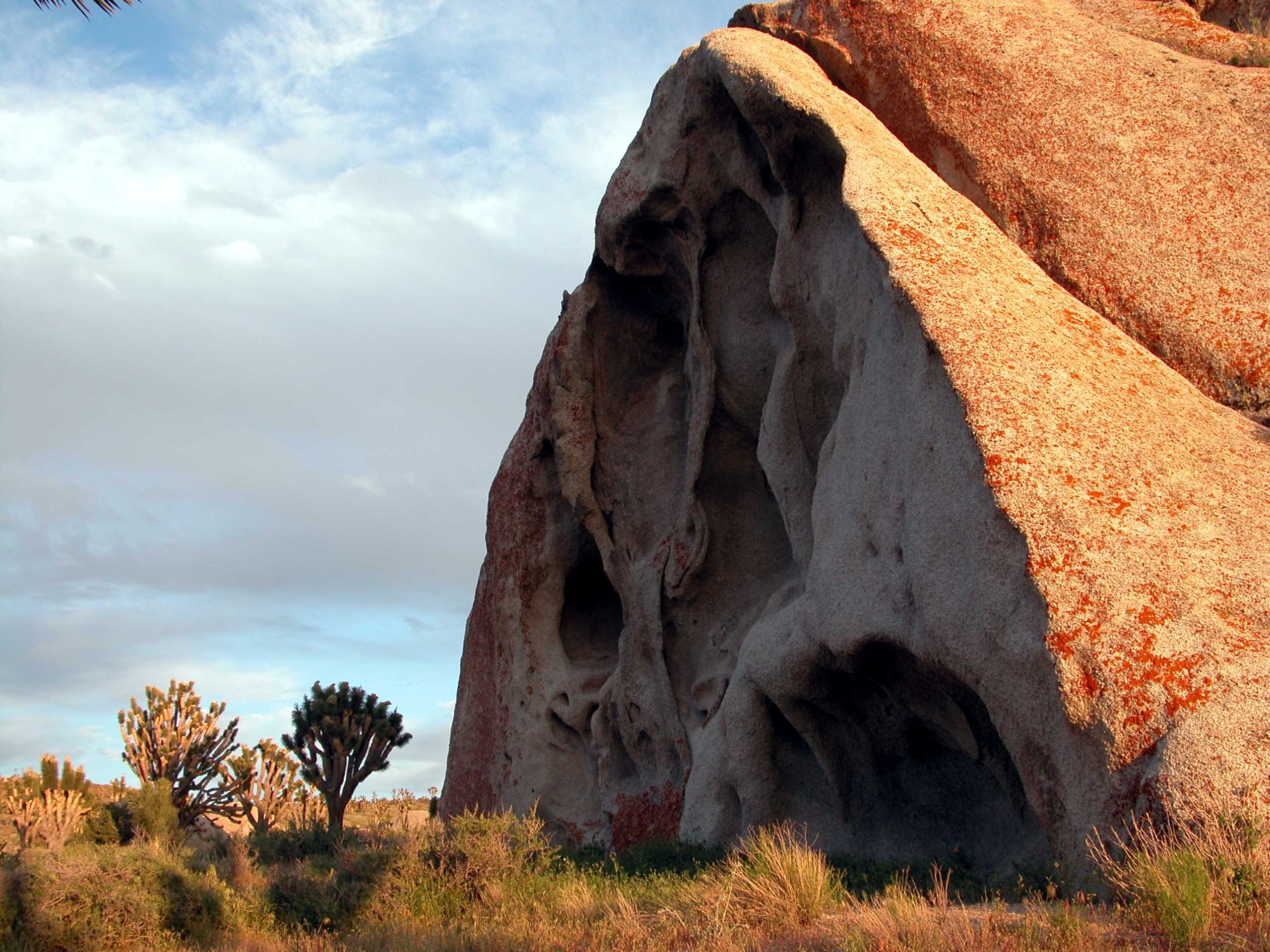
Red rocks frame a stand of Joshua trees and sage brush in the desert floor..
Credit: NPS Photo
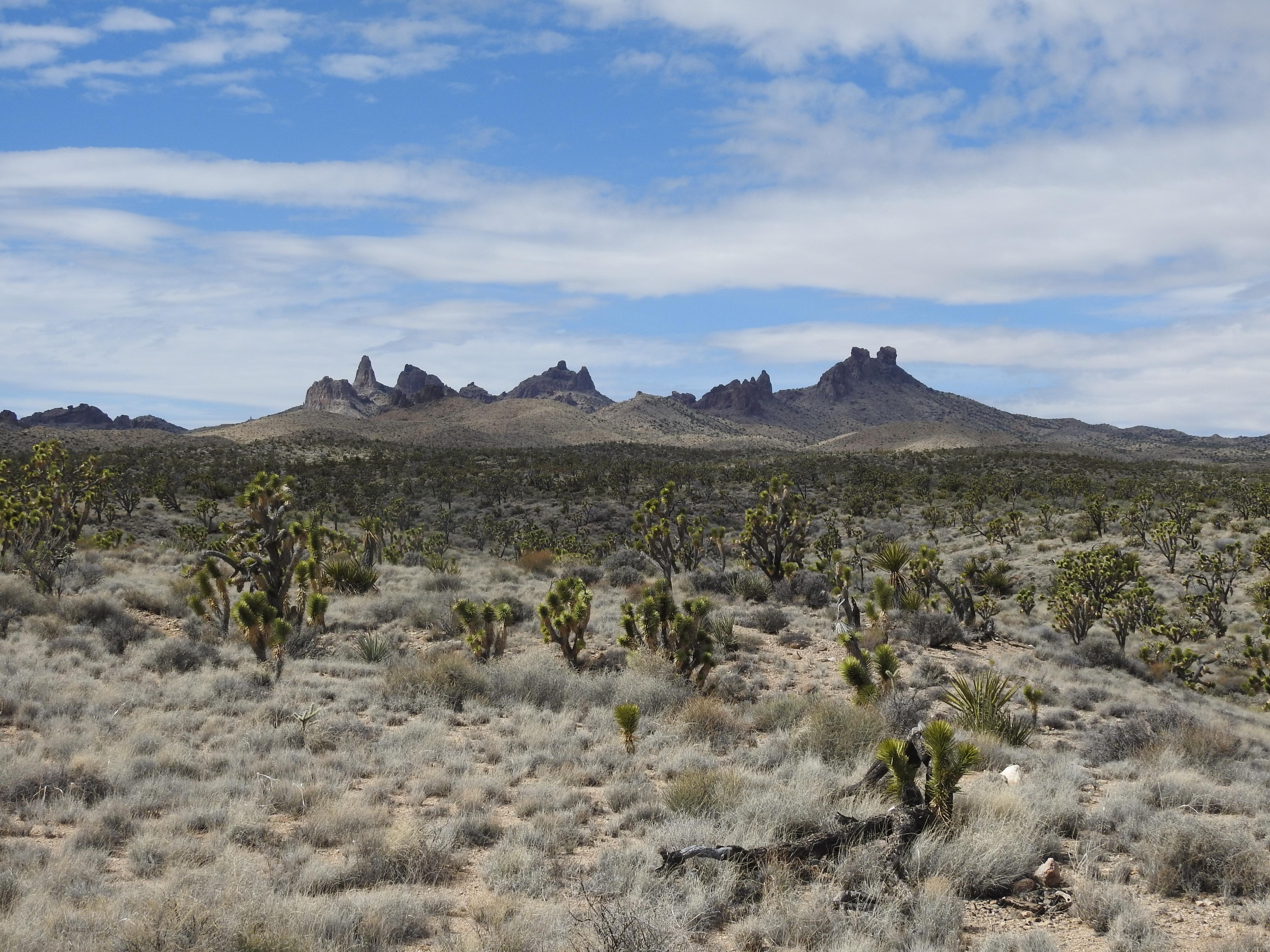
From Walking Box Ranch road, visitors to Castle Mountains can enjoy the stunning view of the Castle Peaks, which are located in surrounding Mojave National Preserve lands.
Credit: NPS Photo
Activities
Topics
Operating Hours
Entrance Fees
No entrance fees listed.
Entrance Passes
No entrance passes listed.
3-Day Weather Forecast
Saturday, Jun 27

Sunny
High: 97.5°F | Low: 73.6°F
Humidity: 18%
Wind: 25.9 mph
Rain Chance: 0%
UV Index: 11.1
Sunrise: 05:27 AM
Sunset: 07:59 PM
Moon: Full Moon (97%)
Visibility: 6 mi
Dew Point: 68.3°F
Cloud Cover: 0%
Pressure: N/A mb
Air Quality (PM2.5): N/A
Ozone: N/A
EPA Index: N/A
Sunday, Jun 28
Sunny
High: 87.8°F | Low: 63.2°F
Humidity: 22%
Wind: 22.4 mph
Rain Chance: 0%
UV Index: 10.3
Sunrise: 05:28 AM
Sunset: 07:59 PM
Moon: Full Moon (100%)
Visibility: 6 mi
Dew Point: 60.3°F
Cloud Cover: 0%
Pressure: N/A mb
Air Quality (PM2.5): N/A
Ozone: N/A
EPA Index: N/A
Monday, Jun 29
Sunny
High: 89.3°F | Low: 64.2°F
Humidity: 12%
Wind: 17 mph
Rain Chance: 0%
UV Index: 10.7
Sunrise: 05:28 AM
Sunset: 07:59 PM
Moon: Full Moon (100%)
Visibility: 6 mi
Dew Point: 59.4°F
Cloud Cover: 0%
Pressure: N/A mb
Air Quality (PM2.5): N/A
Ozone: N/A
EPA Index: N/A
Weather Alerts (5)
Wind Advisory issued June 27 at 2:35AM PDT until June 28 at 5:00AM PDT by NWS San Diego CA
Effective: Jun 27, 2026 5:35am
Expires: Jun 27, 2026 5:15pm
* WHAT...Southwest winds 20 to 30 mph with gusts 40 to 50 mph
expected.
* WHERE...Apple and Lucerne Valleys.
* WHEN...Until 5 AM PDT Sunday.
* IMPACTS...Gusty winds will blow around unsecured objects. Tree
limbs could be blown down and a few power outages may result.
Red Flag Warning issued June 26 at 7:21PM PDT until June 27 at 11:00PM PDT by NWS Las Vegas NV
Effective: Jun 26, 2026 10:21pm
Expires: Jun 27, 2026 5:00pm
...RED FLAG WARNING REMAINS IN EFFECT FOR STRONG WINDS AND LOW
HUMIDITY FOR MUCH OF SOUTHEASTERN CALIFORNIA, SOUTHERN NEVADA,
AND NORTHWESTERN ARIZONA FROM THIS MORNING THROUGH SATURDAY
EVENING...
* TIMING...From now through Saturday evening.
* WIND...Southwest winds 20 to 30 mph with gusts to 40 to 50
mph.
* HUMIDITY...5 to 15 percent.
* IMPACTS...any fires that develop will likely spread rapidly.
Outdoor burning is not recommended. Localized extreme fire
weather conditions exist over eastern portions of Lincoln
county and northern Mohave County this afternoon and evening.
Wind Advisory issued June 26 at 10:53PM PDT until June 28 at 5:00AM PDT by NWS Las Vegas NV
Effective: Jun 27, 2026 1:53am
Expires: Jun 27, 2026 2:00pm
* WHAT...Southwest winds 25 to 35 mph with gusts up to 50 mph.
* WHERE...Portions of northwest Arizona, southeast California, and
south central and southern Nevada.
* WHEN...Until 5 AM PDT /5 AM MST/ Sunday.
* IMPACTS...Gusty winds will blow around unsecured objects. Tree
limbs could be blown down and a few power outages may result.
* ADDITIONAL DETAILS...Winds will diminish overnight Friday into
Saturday before picking back up again Saturday morning. Areas of
blowing dust are possible.
Wind Advisory issued June 26 at 10:53PM PDT until June 27 at 11:00PM PDT by NWS Las Vegas NV
Effective: Jun 27, 2026 1:53am
Expires: Jun 27, 2026 2:00pm
* WHAT...South winds 20 to 30 mph with gusts up to 40 mph are
expected.
* WHERE...In Arizona, portions of Mohave County, including Lake
Havasu and Fort Mohave. In California, portions of San Bernardino
County, including the Colorado River Valley.
* WHEN...From 11 AM PDT /11 AM MST/ to 11 PM PDT /11 PM MST/
Saturday.
* IMPACTS...Gusty winds will blow around unsecured objects. Tree
limbs could be blown down and a few power outages may result.
Wind Advisory issued June 27 at 7:39AM PDT until June 28 at 5:00AM PDT by NWS Las Vegas NV
Effective: Jun 27, 2026 10:39am
Expires: Jun 27, 2026 10:45pm
* WHAT...Southwest winds 25 to 35 mph with gusts up to 50 mph.
* WHERE...Portions of northwest Arizona, southeast California, and
south central and southern Nevada.
* WHEN...Until 5 AM PDT /5 AM MST/ Sunday.
* IMPACTS...Gusty winds will blow around unsecured objects. Tree
limbs could be blown down and a few power outages may result.
* ADDITIONAL DETAILS...Areas of blowing dust are possible as well.
Park Alerts
Visitor Center & Contacts
📍 Physical Address:
Castle Mountains National Monument
2701 Barstow Road
Barstow, CA 92311
🏤 Mailing Address:
Castle Mountains National Monument
2701 Barstow Road
Barstow, CA 92311
📞 Voice Phone: 7602526100
✉️ Email: MOJA_Superintendent@nps.gov