Channel Islands National Park
Designation: National Park
Location: California
📘 Park Overview
Channel Islands National Park encompasses five remarkable islands and their ocean environment, preserving and protecting a wealth of natural and cultural resources. Isolation over thousands of years has created unique animals, plants, and archeological resources found nowhere else on Earth and helped preserve a place where visitors can experience coastal southern California as it once was.
🌤 Weather Information
In general, the islands have a Mediterranean climate year-round. Temperatures are relatively stable, with highs averaging in the mid-60s (°F) and lows in the low-50s. However, there are seasonal differences that visitors should take into consideration when visiting the park. In addition, visitors also should be aware that ocean and weather conditions vary considerably from day-to-day and island-to-island. For more information visit: http://www.nps.gov/chis/planyourvisit/weather.htm
🚗 Directions
While the mainland visitor center in Ventura is readily accessible by car or public transportation, the islands are only accessible by park concessionaire boats and planes or private boat. Advanced planning is highly recommended.
Images
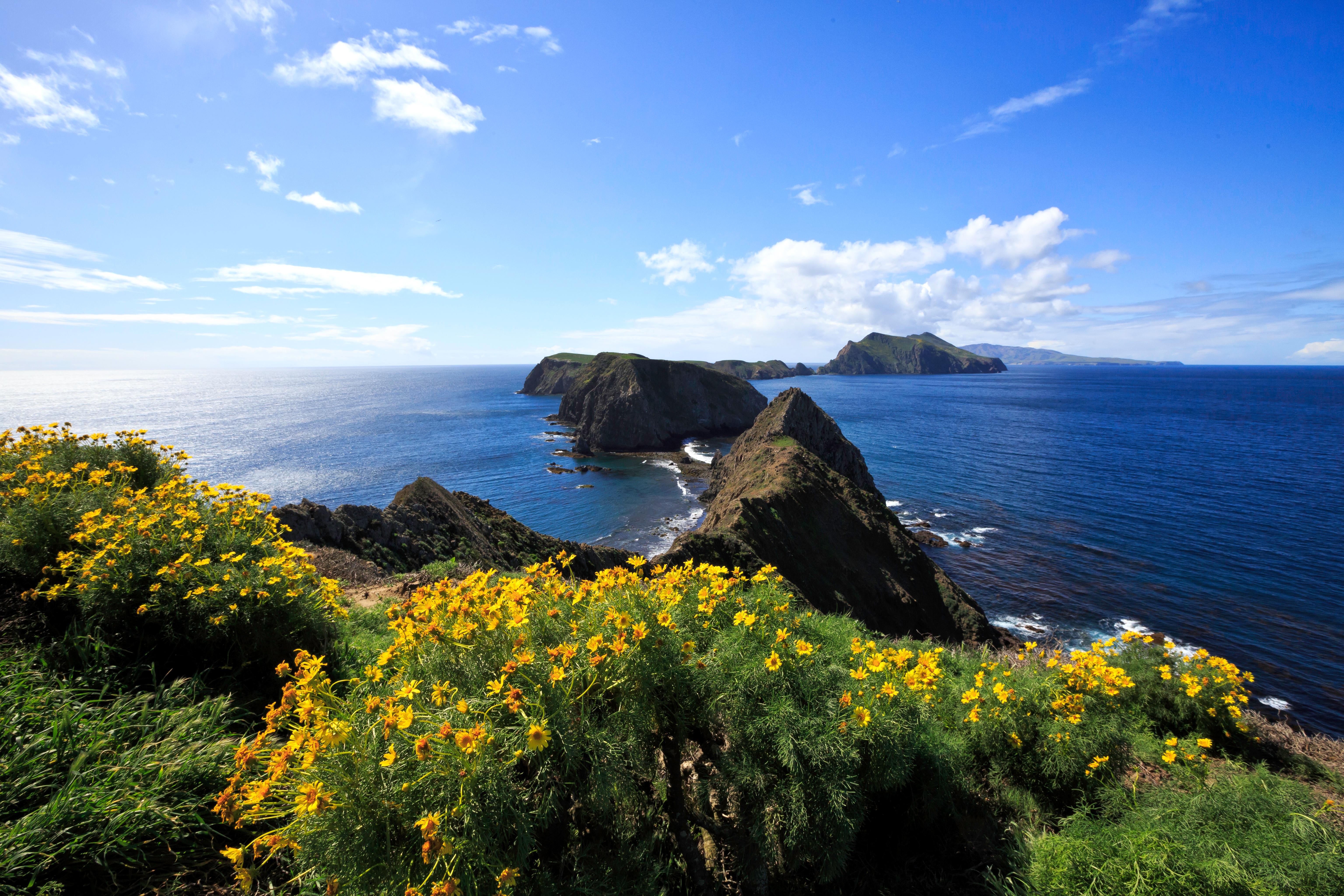
Inspiration Point, Anacapa Island: One of the most spectacular views in the park can be found from Inspiration Point. Looking to the west, one may see Middle and West Anacapa, with Santa Cruz Island in the distance.
Credit: Tim Hauf, timhaufphotography.com
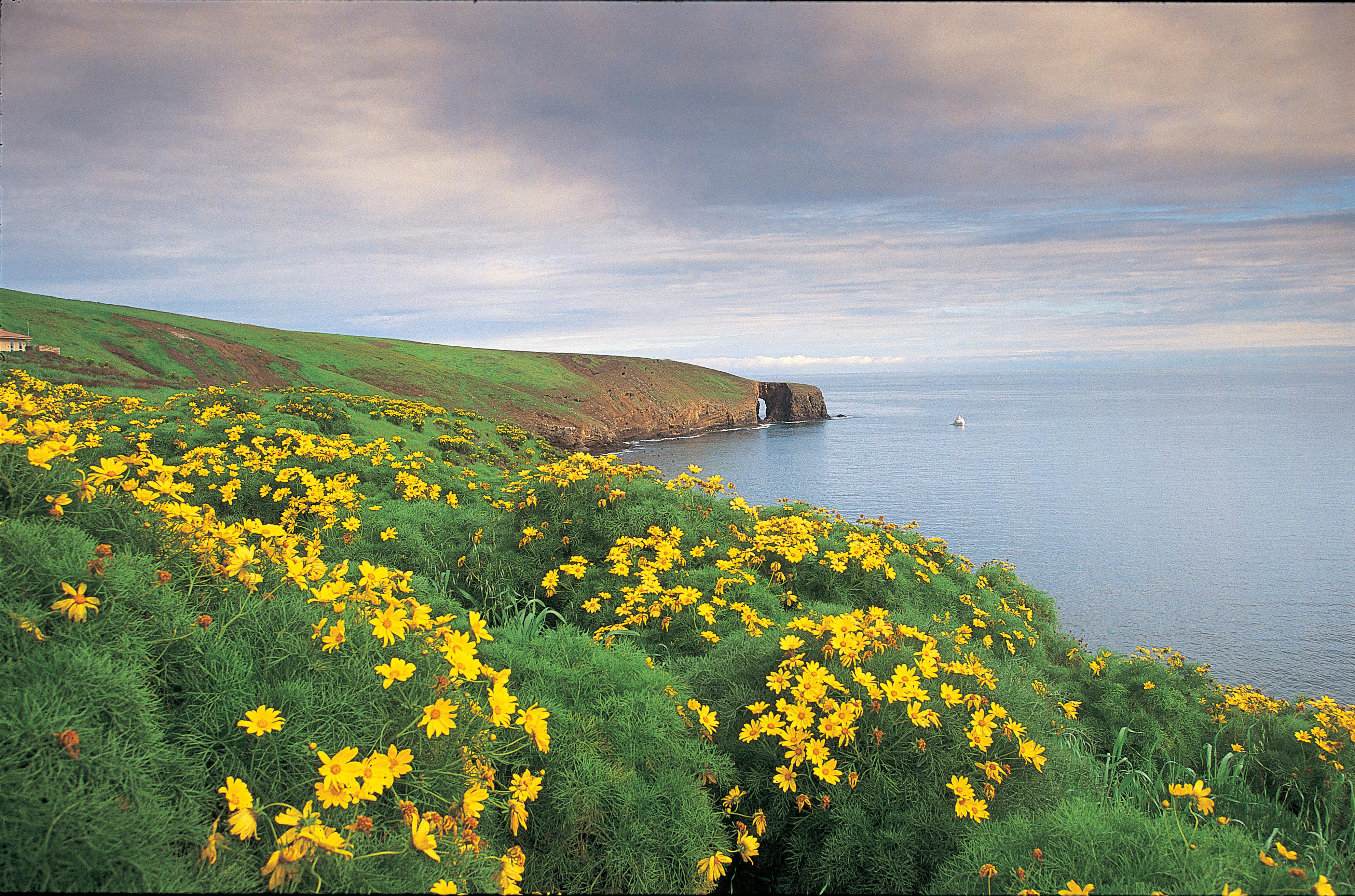
Arch Point, Santa Barbara Island: With winter rains, the coreopsis emerges from summer's dormancy with light green foliage and bright yellow daisy-like flowers
Credit: Tim Hauf, timhaufphotography.com
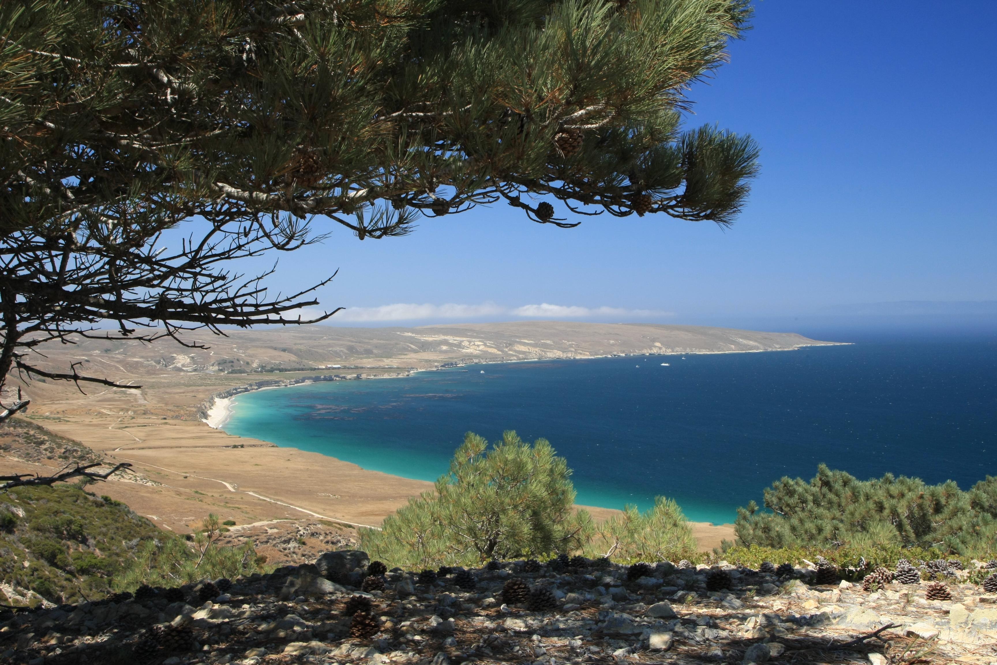
Torrey Pines, Santa Rosa Island: Torrey pines occur naturally in only two locations throughout the world--on the cool, fog drenched northeastern slopes of Bechers Bay and just north of San Diego.
Credit: Tim Hauf, timhaufphotography.com
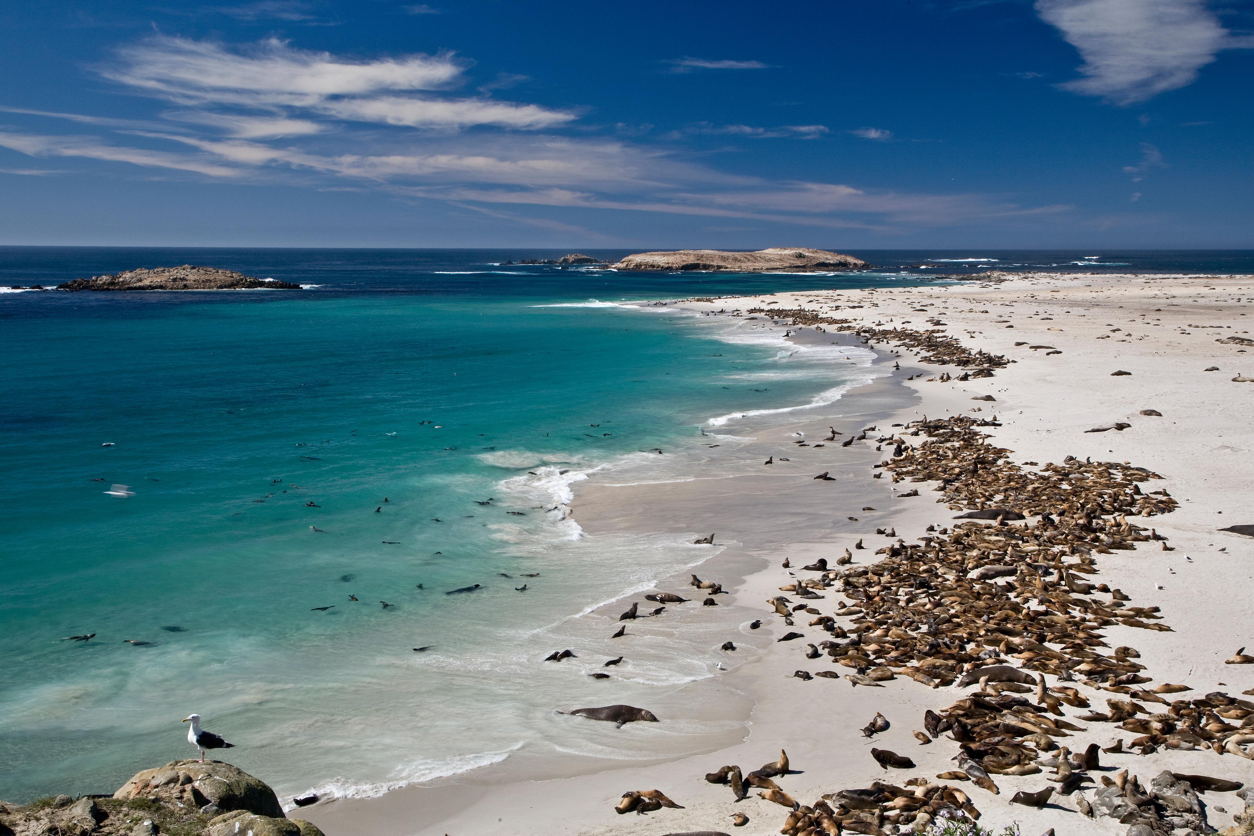
Point Bennet, San Miguel Island: One of the greatest concentrations of wildlife in the world occurs on San Miguel with over 100,000 pinnipeds gathering to breed, pup, and rest.
Credit: Tim Hauf, timhaufphotography.com
Island Fox, Santa Cruz Island: Thousands of years of isolation in a unique island environment has resulted in the development of the endemic island fox, a dwarf form of the mainland gray fox.
Credit: Tim Hauf, timhaufphotography.com
Activities
Topics
Operating Hours
Entrance Fees
No entrance fees listed.
Entrance Passes
No entrance passes listed.
3-Day Weather Forecast
Monday, Jun 8

Sunny
High: 74.1°F | Low: 54.9°F
Humidity: 78%
Wind: 8.1 mph
Rain Chance: 4%
UV Index: 9.7
Sunrise: 05:46 AM
Sunset: 08:10 PM
Moon: Last Quarter (33%)
Visibility: 6 mi
Dew Point: 58.3°F
Cloud Cover: 4%
Pressure: N/A mb
Air Quality (PM2.5): N/A
Ozone: N/A
EPA Index: N/A
Tuesday, Jun 9
Sunny
High: 77.1°F | Low: 56°F
Humidity: 58%
Wind: 6.7 mph
Rain Chance: 1%
UV Index: 10.6
Sunrise: 05:46 AM
Sunset: 08:10 PM
Moon: Waning Crescent (24%)
Visibility: 6 mi
Dew Point: 58.5°F
Cloud Cover: 1%
Pressure: N/A mb
Air Quality (PM2.5): N/A
Ozone: N/A
EPA Index: N/A
Wednesday, Jun 10
Sunny
High: 78.1°F | Low: 58°F
Humidity: 58%
Wind: 6 mph
Rain Chance: 1%
UV Index: 10.4
Sunrise: 05:46 AM
Sunset: 08:11 PM
Moon: Waning Crescent (15%)
Visibility: 6 mi
Dew Point: 60.1°F
Cloud Cover: 1%
Pressure: N/A mb
Air Quality (PM2.5): N/A
Ozone: N/A
EPA Index: N/A
Weather Alerts (3)
Wind Advisory issued June 7 at 6:10PM PDT until June 9 at 12:00AM PDT by NWS Los Angeles/Oxnard CA
Effective: Jun 7, 2026 9:10pm
Expires: Jun 8, 2026 6:15pm
* WHAT...Northwest winds 20 to 30 mph with gusts up to 45 mph
expected.
* WHERE...Santa Barbara County Southwestern Coast and Santa Ynez
Mountains Western Range.
* WHEN...From 5 PM Monday to midnight PDT Monday Night.
* IMPACTS...Gusty winds will blow around unsecured objects. Tree
limbs could be blown down and a few power outages may result.
Beach Hazards Statement issued June 7 at 7:22PM PDT until June 11 at 8:00PM PDT by NWS Los Angeles/Oxnard CA
Effective: Jun 7, 2026 10:22pm
Expires: Jun 8, 2026 12:15pm
* WHAT...Dangerous rip currents and breaking waves due to elevated
surf of 3 to 6 feet with local sets to 7 feet on south facing
beaches.
* WHERE...Ventura County Beaches.
due to elevated
surf of 3 to 6 feet with local sets to 7 feet on south facing
beaches.
* WHEN...From Tuesday morning through Thursday evening.
* IMPACTS...There is an increased risk of ocean drowning. Rip
currents can pull swimmers and surfers out to sea. Waves can
wash people off beaches and rocks, and capsize small boats
nearshore.
Beach Hazards Statement issued June 8 at 1:31AM PDT until June 11 at 8:00PM PDT by NWS Los Angeles/Oxnard CA
Effective: Jun 8, 2026 4:31am
Expires: Jun 8, 2026 7:00pm
* WHAT...Dangerous rip currents and breaking waves due to
elevated surf of 3 to 6 feet with local sets to 7 feet on
south facing beaches.
* WHERE...Ventura County Beaches. due to elevated surf of 3 to 6
feet with local sets to 7 feet on south facing beaches. *
WHEN...From Tuesday morning through Thursday evening.
* IMPACTS...There is an increased risk of ocean drowning. Rip
currents can pull swimmers and surfers out to sea. Waves can
wash people off beaches and rocks, and capsize small boats
nearshore.
Park Alerts
Park Events
Guided Hikes on the Islands
On days that the concessionaire boats run to the islands, guided hikes may be offered by national park rangers, volunteers, or concessionaire naturalists. If they are not available to lead hikes, self-guided interpretive trail booklets are available.
Guided hike locations, distances, and departure times will be announced after your arrival on the island during the visitor orientation.
Please check with a ranger, volunteer, or concessionaire employee for more information.
Location: Park Islands
Date: Jul 11, 2018 12:00am to Jul 11, 2018 12:00am
Paid Event
Visitor Center & Contacts
📍 Physical Address:
1901 Spinnaker Drive
Ventura, CA 93001
🏤 Mailing Address:
1901 Spinnaker Drive
Ventura, CA 93001
📞 Voice Phone: 8056585730
📞 Fax Phone: 8056585799
✉️ Email: chis_information@nps.gov