Potomac Heritage National Scenic Trail
Designation: National Scenic Trail
Location: District of Columbia, Maryland, Pennsylvania, Virginia
📘 Park Overview
The Potomac River corridor is rich in both history and recreation, offering a chance to both explore your heritage and choose your adventure along the way. Start your journey here!
🌤 Weather Information
Weather associated with the PHT network is typical of a temperate climate, with four distinct seasons and variable precipitation throughout the year. Temperatures can vary from a high of 100 degrees Fahrenheit in the summer to 0 degrees in the winter.
🚗 Directions
The administrative office for the NPS Potomac Heritage NST is located at the Chesapeake and Ohio Canal National Historical Park headquarters.
Images

Watch the sunset over the Potomac River
Credit: NPS Photo / Steve Dean
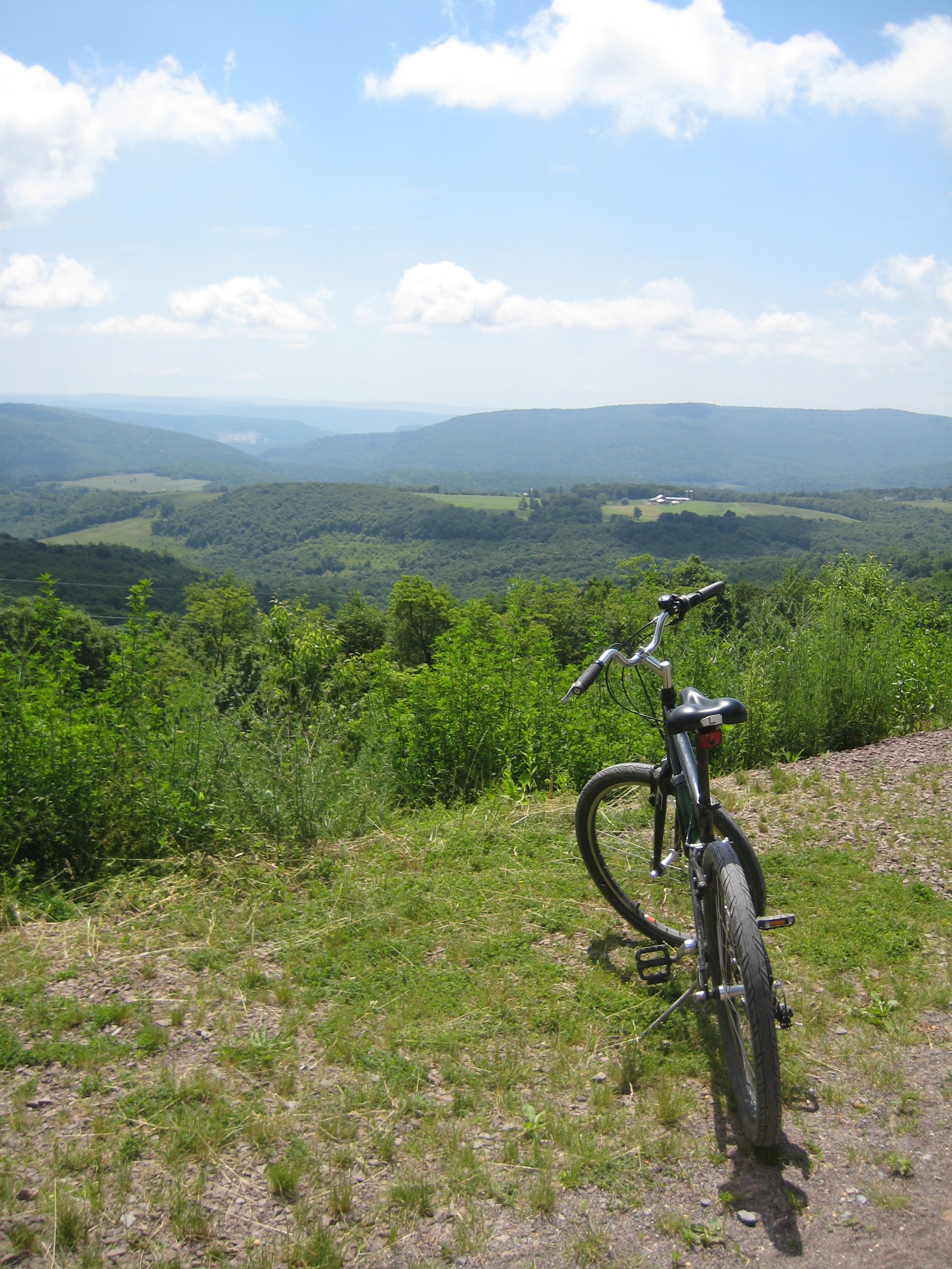
Great Allegheny Passage is a bicyclist enthusiasts' dream come true!
Credit: NPS Photo

Bluebells flowering on the towpath
Credit: NPS Photo / Stephanie Spencer
Watch the sunset over the Potomac River
Credit: NPS Photo / Steve Dean
Great Allegheny Passage is a bicyclist enthusiasts' dream come true!
Credit: NPS Photo
Bluebells flowering on the towpath
Credit: NPS Photo / Stephanie Spencer
Watch the sunset over the Potomac River
Credit: NPS Photo / Steve Dean
Great Allegheny Passage is a bicyclist enthusiasts' dream come true!
Credit: NPS Photo
Bluebells flowering on the towpath
Credit: NPS Photo / Stephanie Spencer
Watch the sunset over the Potomac River
Credit: NPS Photo / Steve Dean
Activities
Topics
Operating Hours
Entrance Fees
No entrance fees listed.
Entrance Passes
No entrance passes listed.
3-Day Weather Forecast
Monday, Mar 16

Heavy rain
High: 67.8°F | Low: 34.3°F
Humidity: 91%
Wind: 21.5 mph
Rain Chance: 89%
UV Index: 0.5
Sunrise: 07:20 AM
Sunset: 07:19 PM
Moon: Waning Crescent (11%)
Visibility: 5 mi
Dew Point: 57.3°F
Cloud Cover: 89%
Pressure: N/A mb
Air Quality (PM2.5): N/A
Ozone: N/A
EPA Index: N/A
Tuesday, Mar 17

Light freezing rain
High: 42.1°F | Low: 26.3°F
Humidity: 52%
Wind: 17.2 mph
Rain Chance: 67%
UV Index: 0.8
Sunrise: 07:19 AM
Sunset: 07:20 PM
Moon: Waning Crescent (5%)
Visibility: 6 mi
Dew Point: 23.8°F
Cloud Cover: 67%
Pressure: N/A mb
Air Quality (PM2.5): N/A
Ozone: N/A
EPA Index: N/A
Wednesday, Mar 18

Overcast
High: 39.6°F | Low: 25.3°F
Humidity: 53%
Wind: 9.8 mph
Rain Chance: 0%
UV Index: 1
Sunrise: 07:17 AM
Sunset: 07:21 PM
Moon: Waning Crescent (1%)
Visibility: 6 mi
Dew Point: 22.2°F
Cloud Cover: 0%
Pressure: N/A mb
Air Quality (PM2.5): N/A
Ozone: N/A
EPA Index: N/A
Weather Alerts (5)
Special Weather Statement issued March 16 at 11:28AM EDT by NWS Baltimore MD/Washington DC
Effective: Mar 16, 2026 11:28am
Expires: Mar 16, 2026 7:00pm
The National Weather Service in Sterling, Virginia has activated the
SKYWARN amateur radio network for Tornado Watch number 67. Severe
thunderstorms will be capable of producing tornadoes, damaging
wind gusts,and hail. Weather spotters are encouraged to relay any
severe storm impacts to the National Weather Service in Sterling,
Virginia.
Tornado Watch issued March 16 at 10:58AM EDT until March 16 at 7:00PM EDT by NWS Baltimore MD/Washington DC
Effective: Mar 16, 2026 10:58am
Expires: Mar 16, 2026 7:00pm
THE NATIONAL WEATHER SERVICE HAS ISSUED TORNADO WATCH 67 IN
EFFECT UNTIL 7 PM EDT THIS EVENING FOR THE FOLLOWING AREAS
THE DISTRICT OF COLUMBIA
IN MARYLAND THIS WATCH INCLUDES 14 COUNTIES
IN CENTRAL MARYLAND
ANNE ARUNDEL HOWARD
MONTGOMERY
PRINCE GEORGES
IN NORTH CENTRAL MARYLAND
CARROLL FREDERICK
WASHINGTON
IN NORTHEAST MARYLAND
CECIL
IN NORTHERN MARYLAND
BALTIMORE
BALTIMORE CITY
HARFORD
IN SOUTHERN MARYLAND
CALVERT CHARLES
ST. MARYS
IN VIRGINIA THIS WATCH INCLUDES 21 COUNTIES
IN CENTRAL VIRGINIA
CITY OF FREDERICKSBURG
KING GEORGE ORANGE
SPOTSYLVANIA
IN NORTHERN VIRGINIA
ARLINGTON
CITY OF ALEXANDRIA
CITY OF FAIRFAX
CITY OF FALLS CHURCH
CITY OF MANASSAS
CITY OF MANASSAS PARK
CULPEPER FAIRFAX
FAUQUIER LOUDOUN
PRINCE WILLIAM
STAFFORD
IN NORTHWEST VIRGINIA
CITY OF WINCHESTER
CLARKE FREDERICK
RAPPAHANNOCK WARREN
IN WEST VIRGINIA THIS WATCH INCLUDES 3 COUNTIES
IN PANHANDLE WEST VIRGINIA
BERKELEY JEFFERSON
MORGAN
THIS INCLUDES THE CITIES OF ABERDEEN, ALEXANDRIA, ANNAPOLIS,
ARLINGTON, ARNOLD, ASPEN HILL, BALLENGER CREEK, BALTIMORE,
BEL AIR, BERRYVILLE, BETHESDA, BOWIE, CALIFORNIA, CAMP SPRINGS,
CATONSVILLE, CHANTILLY, CHARLES TOWN, CHESAPEAKE BEACH, CLINTON,
COLLEGE PARK, COLUMBIA, CULPEPER, DAHLGREN, DUNDALK, DUNKIRK,
EDGEWOOD, ELDERSBURG, ELKTON, ELLICOTT CITY, ESSEX, FAIRFAX,
FALLS CHURCH, FALLSTON, FALMOUTH, FREDERICK, FREDERICKSBURG,
FRONT ROYAL, GAITHERSBURG, GERMANTOWN, GLEN BURNIE, GORDONSVILLE,
GREENBELT, HAGERSTOWN, HAVRE DE GRACE, HERNDON, HUNTINGTOWN,
JOPPATOWNE, LAUREL, LEESBURG, LEXINGTON PARK, LUSBY, MANASSAS,
MANASSAS PARK, MARTINSBURG, MCLEAN, NORTH BEACH, ODENTON, ORANGE,
PARKVILLE, PAW PAW, PIKESVILLE, POTOMAC, PRINCE FREDERICK,
RANDALLSTOWN, RESTON, ROCKVILLE, SEVERN, SEVERNA PARK,
SHEPHERDSTOWN, SILVER SPRING, SOUTH GATE,
SPOTSYLVANIA COURTHOUSE, ST. CHARLES, STERLING,
SUITLAND-SILVER HILL, TOWSON, WALDORF, WARRENTON, WASHINGTON,
WASHINGTON, WESTMINSTER, WINCHESTER, WINCHESTER, AND WOODBRIDGE.
Effective: Mar 16, 2026 2:27pm
Expires: Mar 16, 2026 2:37pm
Monitoring message only. Please disregard.
Severe Thunderstorm Warning issued March 16 at 2:11PM EDT until March 16 at 2:45PM EDT by NWS Baltimore MD/Washington DC
Effective: Mar 16, 2026 2:11pm
Expires: Mar 16, 2026 2:45pm
SVRLWX
The National Weather Service in Sterling Virginia has issued a
* Severe Thunderstorm Warning for...
Northwestern Anne Arundel County in central Maryland...
Eastern Howard County in central Maryland...
Southeastern Montgomery County in central Maryland...
Northwestern Prince Georges County in central Maryland...
* Until 245 PM EDT.
* At 210 PM EDT, a severe thunderstorm was located over Langley Park,
moving east at 55 mph.
HAZARD...60 mph wind gusts.
SOURCE...Radar indicated.
IMPACT...Damaging winds will cause some trees and large branches
to fall. This could injure those outdoors, as well as
damage homes and vehicles. Roadways may become blocked by
downed trees. Localized power outages are possible.
Unsecured light objects may become projectiles.
* Locations impacted include...
Columbia, Severn, Olney, College Park, Langley Park, Beltsville,
Elkridge, Historic Ellicott City, Ellicott City, Aspen Hill,
Catonsville, Woodlawn, Odenton, Laurel, Fairland, White Oak,
Adelphi, Colesville, Kemp Mill, and Chevy Chase.
Severe Thunderstorm Warning issued March 16 at 2:16PM EDT until March 16 at 3:00PM EDT by NWS Baltimore MD/Washington DC
Effective: Mar 16, 2026 2:16pm
Expires: Mar 16, 2026 3:00pm
SVRLWX
The National Weather Service in Sterling Virginia has issued a
* Severe Thunderstorm Warning for...
Northwestern St. Marys County in southern Maryland...
Southwestern Prince Georges County in central Maryland...
Charles County in southern Maryland...
Southeastern Stafford County in northern Virginia...
King George County in central Virginia...
Southeastern Fairfax County in northern Virginia...
East central Spotsylvania County in central Virginia...
* Until 300 PM EDT.
* At 216 PM EDT, a severe thunderstorm was located near Potomac
Creek, moving northeast at 45 mph.
HAZARD...60 mph wind gusts.
SOURCE...Radar indicated.
IMPACT...Damaging winds will cause some trees and large branches
to fall. This could injure those outdoors, as well as
damage homes and vehicles. Roadways may become blocked by
downed trees. Localized power outages are possible.
Unsecured light objects may become projectiles.
* Locations impacted include...
Waldorf, Fort Washington, La Plata, King George, Dahlgren, Fairview
Beach, Nanjemoy Creek, Popes Creek, Aquia Creek, Potomac Creek,
Port Tobacco River, Saint Charles, Wicomico, Accokeek, Bryans Road,
Brandywine, Hughesville, Mason Neck, Passapatanzy, and Potomac
Heights.
Park Alerts
Visitor Center & Contacts
📍 Physical Address:
Potomac Heritage National Scenic Trail
c/o Chesapeake and Ohio Canal National Historical Park
Williamsport, MD 21795
🏤 Mailing Address:
Potomac Heritage National Scenic Trail
c/o Chesapeake and Ohio Canal National Historical Park
Williamsport, MD 21795
📞 Voice Phone: 301-739-4200
✉️ Email: POHE_information@nps.gov