Saint-Gaudens National Historical Park
Designation: National Historical Park
Location: New Hampshire
📘 Park Overview
Your National Park for the Arts preserves the home and studio of sculptor Augustus Saint-Gaudens (1848-1907). Here stories flow through a landscape of inspiration. Discover the history behind the captivating bronze sculptures and enjoy the beauty of art and nature. The park and its partners continue the tradition of the Cornish Colony of artists. Unleash your creativity today.
🌤 Weather Information
The upper Connecticut River valley is located in a temperate climate. While some summer days may be hot and humid, the average summer temperature ranges in the 70s and lower 80s. Temperatures in the fall are normally in the upper 60s, with evenings dropping into the upper 40s and lower 50s. Winters can be cold with daily temperatures usually in the 20s and occasionally dropping to below zero. Snow may be heavy from mid December through March.
🚗 Directions
From West Lebanon, NH, (at Exit 20 of Interstate Rt 89) take Route 12A south for about 12 miles, Saint-Gaudens Road will be on the left. Proceed up Saint-Gaudens Road .5 miles. The parking lot will be on your right. From Windsor, Vermont, For passenger vehicles, take bridge Street cross the Connecticut River via the covered bridge. Caution: the bridge is closed to RVs, trucks and busses. At the end of the covered Bridge in New Hampshire, turn left. Saint Gaudens Road will be on you right in one mile.
Images
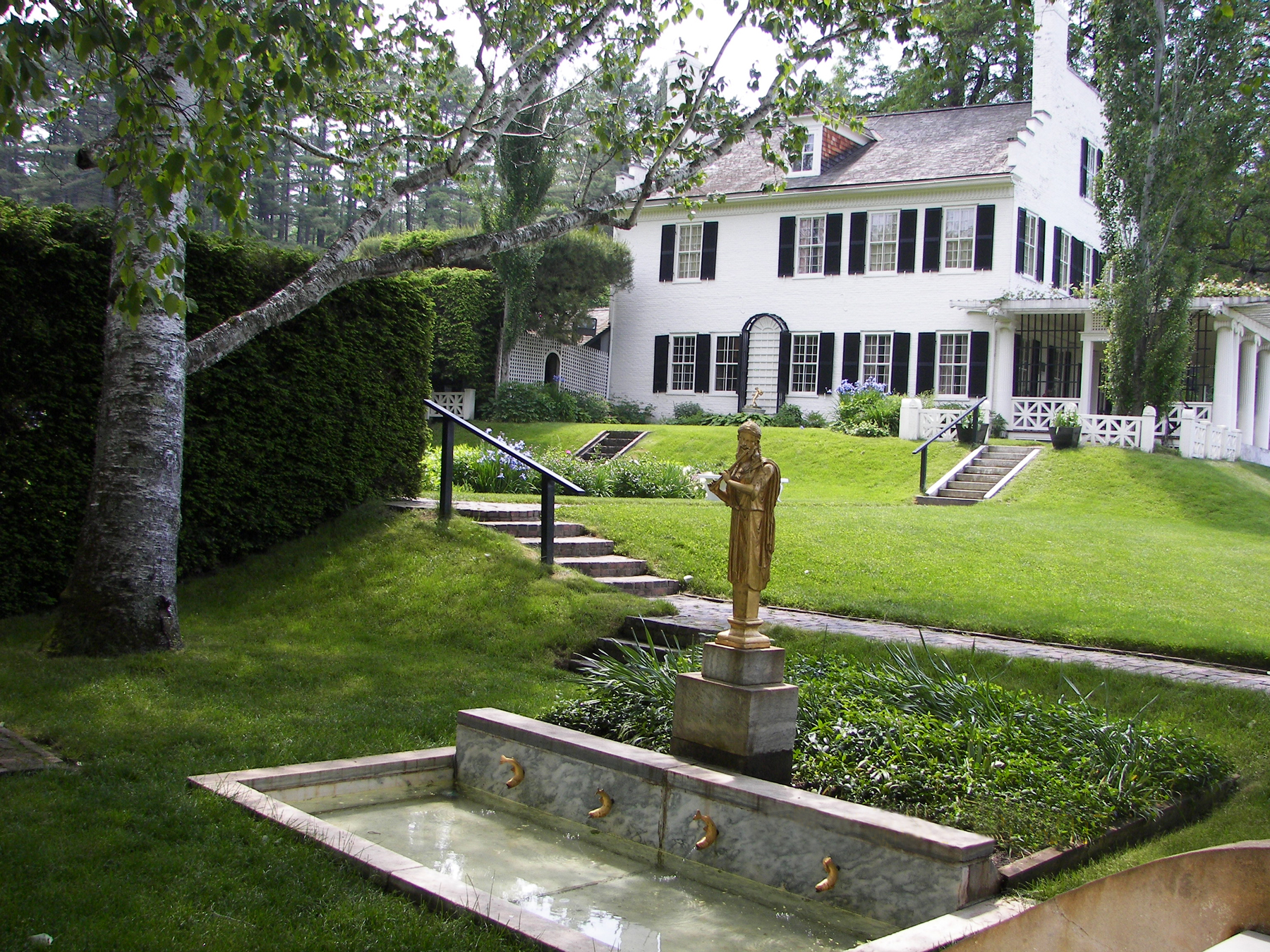
Built in 1817, Saint-Gaudens came here in 1885. He named it Aspet after the birthplace of his father in France.
Credit: NPS Photo
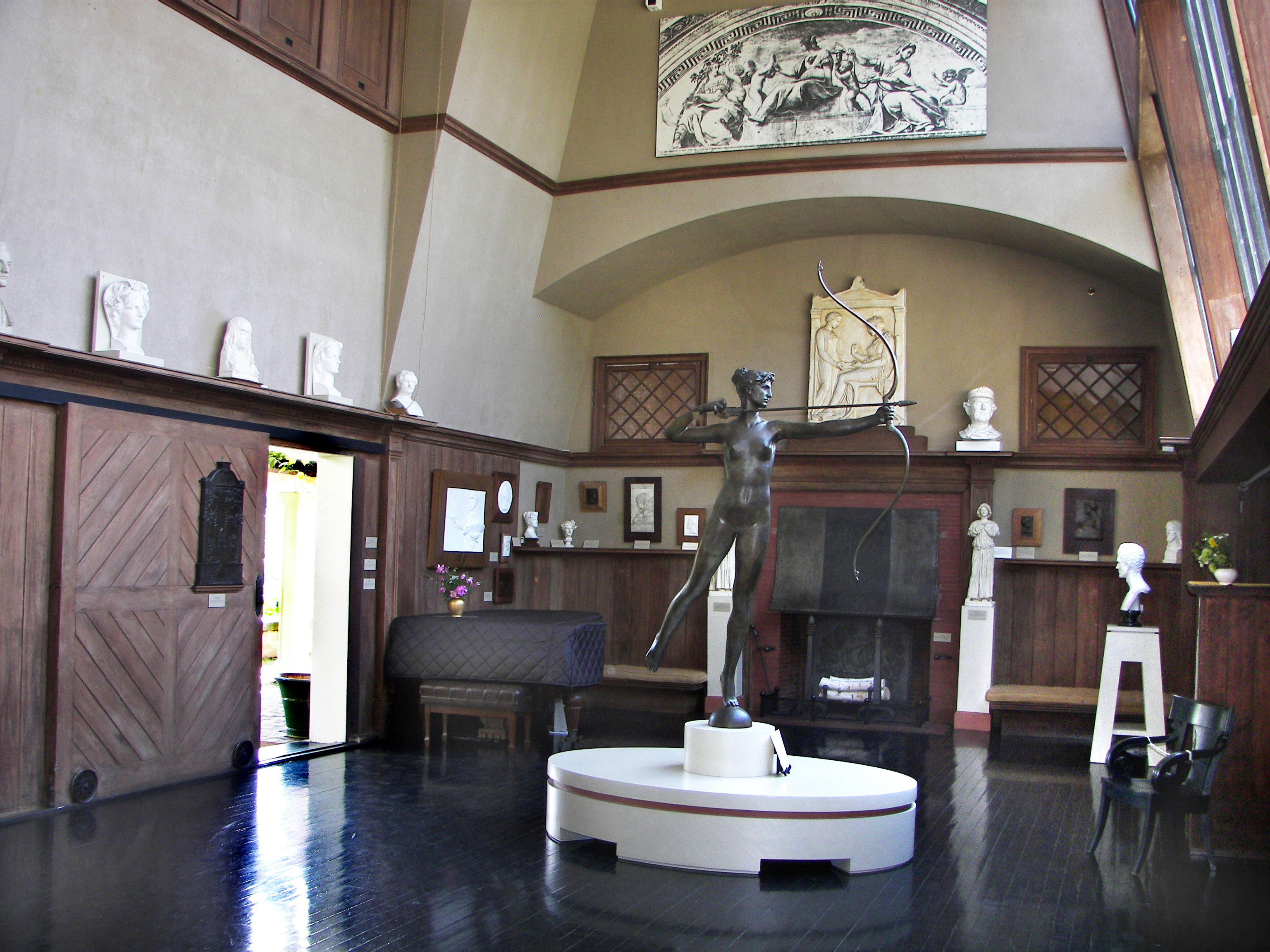
The Little Studio where Augustus Saint-Gaudens worked, exhibits some his well known works.
Credit: NPS Photo
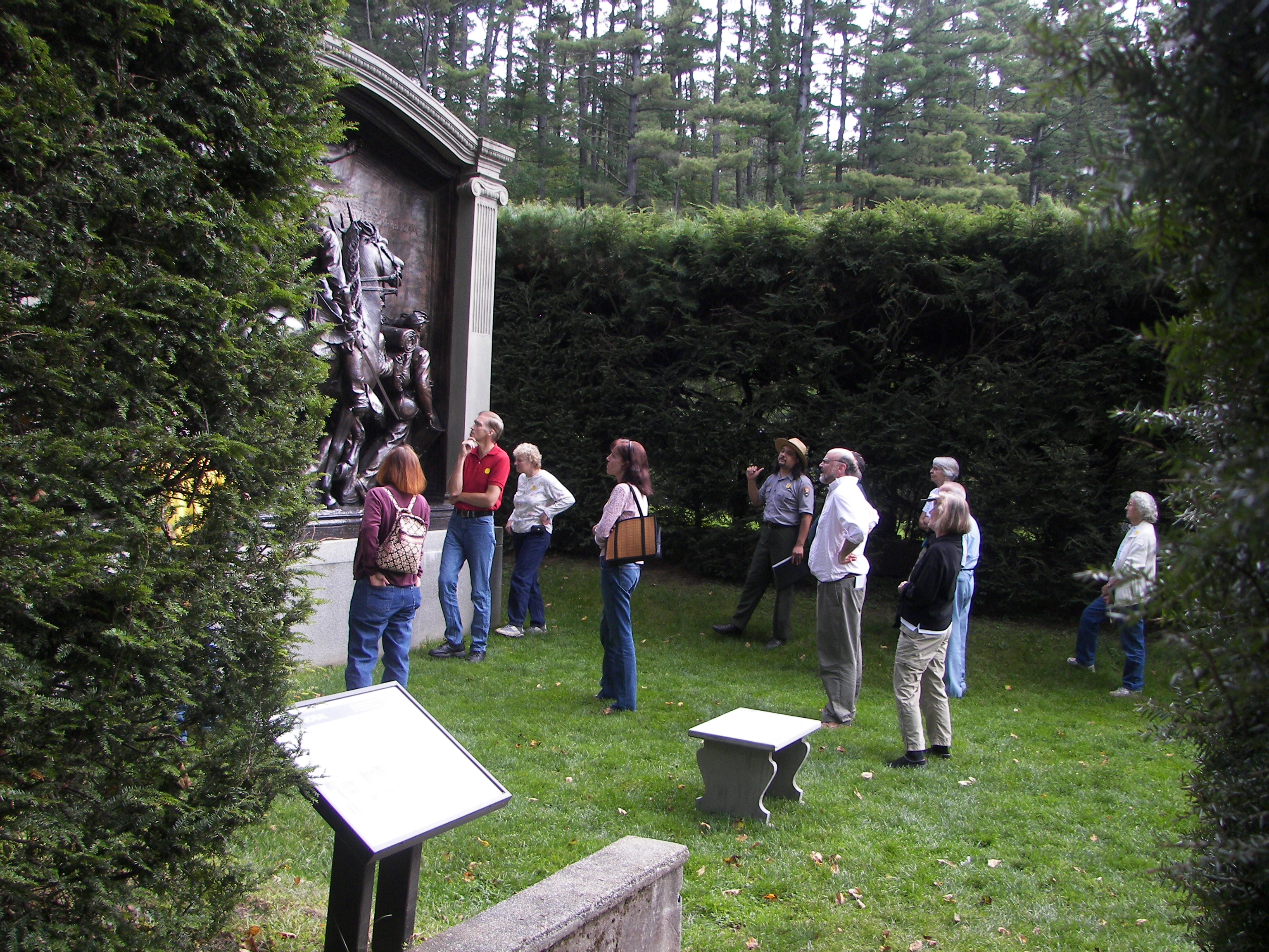
Visitors looking at the bronze cast of the Shaw Memorial, Saint-Gaudens' masterpiece.
Credit: NPS Photo
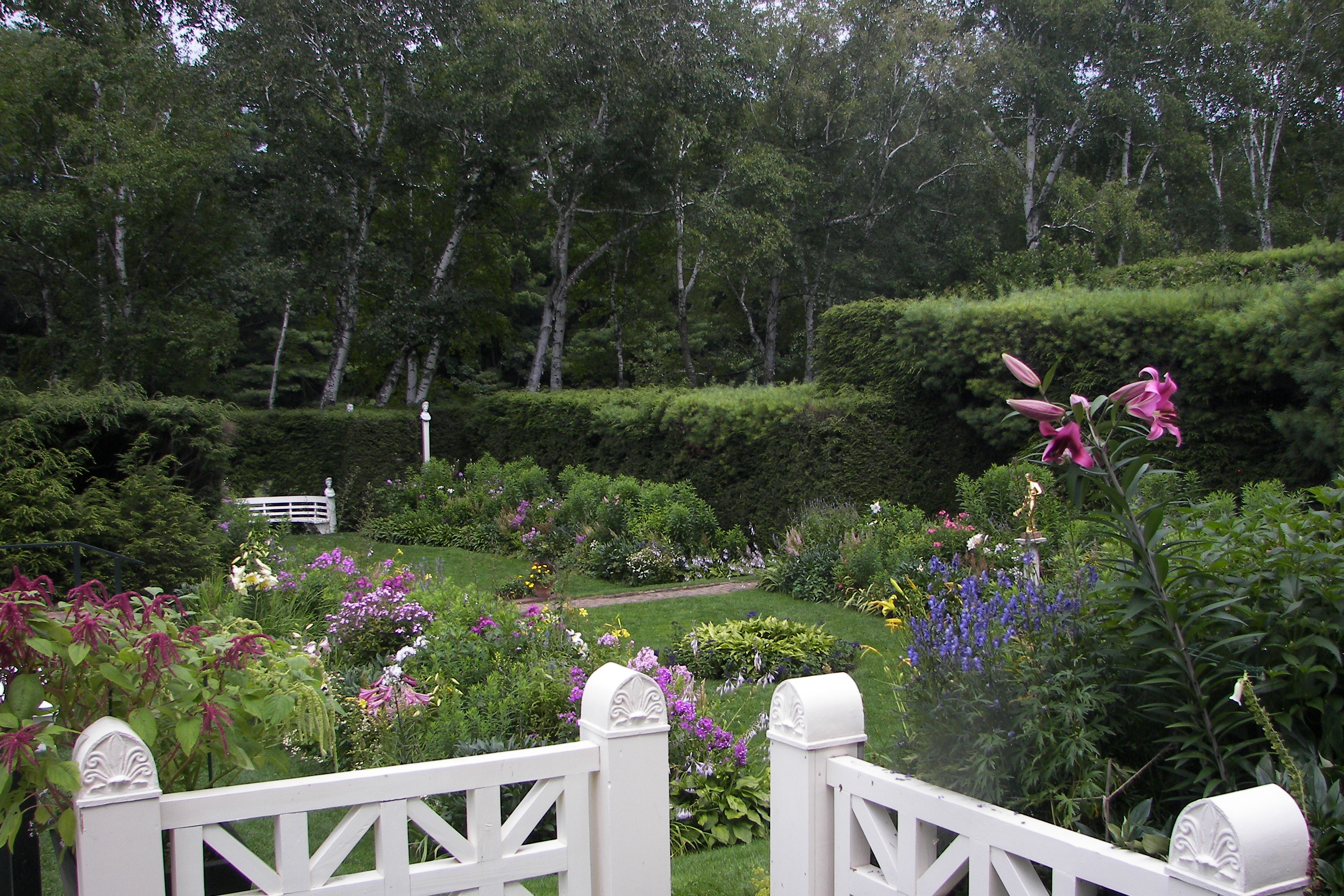
The Formal Gardens remain much like they were in the artist's time.
Credit: NPS Photo
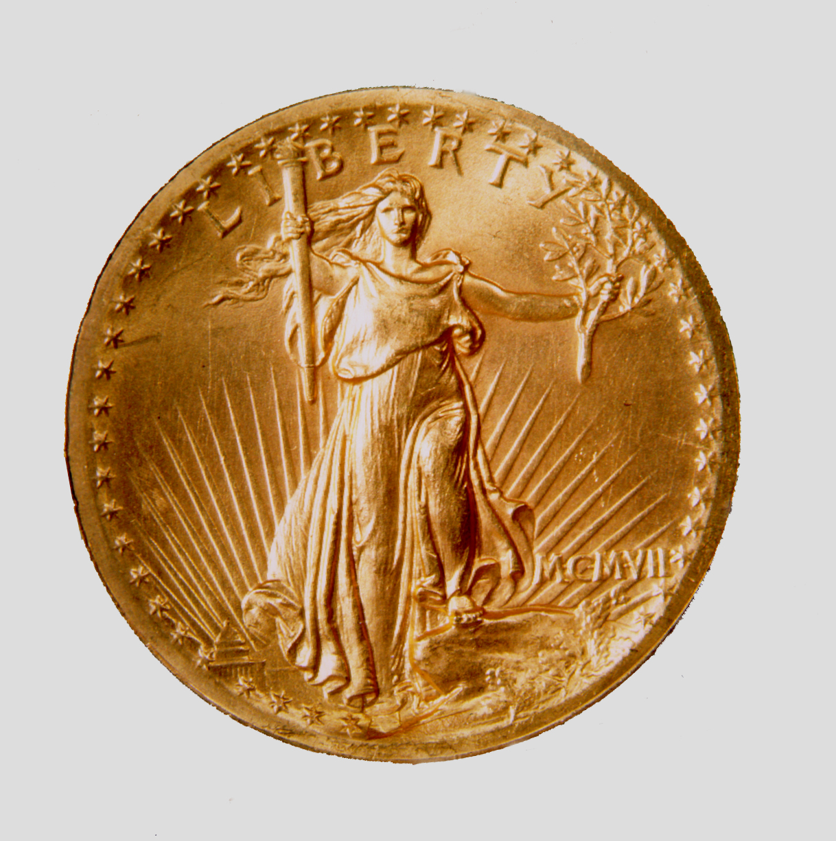
The 20 dollar gold piece Saint-Gaudens designed, is considered the most beautiful American coin ever minted
Credit: NPS Photo
Activities
Topics
Operating Hours
Entrance Fees
Entrance Passes
3-Day Weather Forecast
Wednesday, Jul 8

Sunny
High: 81.7°F | Low: 53.1°F
Humidity: 62%
Wind: 5.4 mph
Rain Chance: 4%
UV Index: 8.5
Sunrise: 05:16 AM
Sunset: 08:32 PM
Moon: Waning Crescent (28%)
Visibility: 4 mi
Dew Point: 59.2°F
Cloud Cover: 4%
Pressure: N/A mb
Air Quality (PM2.5): N/A
Ozone: N/A
EPA Index: N/A
Thursday, Jul 9
Sunny
High: 83.8°F | Low: 64.4°F
Humidity: 63%
Wind: 8.7 mph
Rain Chance: 5%
UV Index: 8.3
Sunrise: 05:17 AM
Sunset: 08:31 PM
Moon: Waning Crescent (19%)
Visibility: 6 mi
Dew Point: 66.7°F
Cloud Cover: 5%
Pressure: N/A mb
Air Quality (PM2.5): N/A
Ozone: N/A
EPA Index: N/A
Friday, Jul 10

Patchy rain nearby
High: 77.4°F | Low: 63.5°F
Humidity: 82%
Wind: 7.8 mph
Rain Chance: 69%
UV Index: 7.4
Sunrise: 05:18 AM
Sunset: 08:31 PM
Moon: Waning Crescent (12%)
Visibility: 4 mi
Dew Point: 66.5°F
Cloud Cover: 69%
Pressure: N/A mb
Air Quality (PM2.5): N/A
Ozone: N/A
EPA Index: N/A
Park Alerts
Park Events
Community Science Volunteer Day: Hemlock Wooly Adelgid Monitoring
Join natural resources staff to help monitor trees for the presence of Hemlock wooly adelgid (HWA).
Hemlock woolly adelgid (HWA) is an invasive aphid-like insect that feeds on hemlock trees, resulting in the tree’s defoliation and eventual death. While HWA has been confirmed in Windsor County, VT and Sullivan County, NH, the National Park Service has yet to detect it at Marsh-Billings-Rockefeller NHP or Saint-Gaudens NHP. Considering the substantial risks that HWA poses to hemlocks, the parks conduct annual monitoring. Any early detection will allow natural resource staff to protect these invaluable trees and we need your help.
Volunteer to assist natural resource staff inspect hemlock branches at 12 different monitoring location. Monitoring at Saint-Gaudens NHP will be held on Thursday April 2 from 9am to 1pm. Additionally, monitoring at Marsh-Billings-Rockefeller NHP will be on Friday, April 3 and Saturday, April 4 from 9am to 1pm. Volunteers may sign-up to volunteer for 1, 2, or 3 days - please indicate your preference when you register.
Be prepared to hike on and off trail over rough, steep, and uneven terrain in the snow. Please dress appropriately for outdoor weather. Bring a water bottle, snack, and snowshoes/microspikes if possible. This event will continue snow or shine. We will have adult and children’s snowshoes as well as microspikes available if needed.
What to bring:
- Winter boots (sneakers not recommended; expect snow)
- Snowshoes or microspikes (if you have them)
- Trekking poles (if you have them)
- Water bottle
- Snacks
- Small day pack or hip pack
- Warm clothing and layers
Registration is required by submitting a volunteer application, emailing the park, or calling 802-457-3368. Volunteers must be age 16 and above. Anyone under age 18 must be accompanied by a legal guardian.
Date: Apr 2, 2026 12:00am to Apr 2, 2026 12:00am
Paid Event
Beyond the Bronze
Recasts, or copies, of monuments by Augustus Saint-Gaudens from across the country now stand throughout the park. Join this ranger-guided program to explore the sculptures that helped forge an American identity in the Gilded Age and beyond. As the nation commemorates its 250th anniversary, this program shares the stories of people connected to these iconic works and their significance today.
Location: This program begins outside the visitor center and moves across the park's historic core area. It includes walking on mowed grass and sometimes uneven ground.
Date: May 23, 2026 12:00am to May 23, 2026 12:00am
Paid Event
Aspet Open House
Step inside the home of Augustus and Augusta Saint-Gaudens. A docent will be available to answer questions and share history about the home, family, and Cornish Colony of artists.
Location: Aspet is the large white, brick building in the park's core area. The West Porch is located on the side of the building furthest from the visitor center. It is oriented to face the large open field and view of Mount Ascutney in the distance.
Date: May 23, 2026 12:00am to Oct 13, 2026 12:00am
Paid Event
Beyond the Bronze
Recasts, or copies, of monuments by Augustus Saint-Gaudens from across the country now stand throughout the park. Join this ranger-guided program to explore the sculptures that helped forge an American identity in the Gilded Age and beyond. As the nation commemorates its 250th anniversary, this program shares the stories of people connected to these iconic works and their significance today.
Location: This program begins outside the visitor center and moves across the park's historic core area. It includes walking on mowed grass and sometimes uneven ground.
Date: May 24, 2026 12:00am to May 24, 2026 12:00am
Paid Event
Beyond the Bronze
Recasts, or copies, of monuments by Augustus Saint-Gaudens from across the country now stand throughout the park. Join this ranger-guided program to explore the sculptures that helped forge an American identity in the Gilded Age and beyond. As the nation commemorates its 250th anniversary, this program shares the stories of people connected to these iconic works and their significance today.
Location: This program begins outside the visitor center and moves across the park's historic core area. It includes walking on mowed grass and sometimes uneven ground.
Date: May 25, 2026 12:00am to May 25, 2026 12:00am
Paid Event
Visitor Center & Contacts
📍 Physical Address:
139 Saint Gaudens Road
Cornish, NH 03745
🏤 Mailing Address:
139 Saint Gaudens Road
Cornish, NH 03745
📞 Voice Phone: 603-675-2175
✉️ Email: saga_info@nps.gov