← Back to Search

Statue Of Liberty National Monument

Designation: National Monument

Location: New York

Visit Official Park Website

📘 Park Overview

A gift of friendship from the people of France to the United States "The Statue of Liberty Enlightening the World" is recognized as a universal symbol of freedom and democracy. It was dedicated by President Grover Cleveland on October 28, 1886. Designated as a National Monument in 1924, employees of the National Park Service have been caring for the Statue of Liberty since 1933.

🌤 Weather Information

It is typically colder and more windy in New York Harbor than elsewhere in New York City. Winters are cold and damp. Spring and Fall can range from chilly to warm. Summers are warm to hot and humid.

🚗 Directions

Liberty Island is located in New York Harbor and can only be reached by ferry. Ferries operated by Statue City Cruises depart from The Battery in New York City or Liberty State Park in Jersey City, NJ.

Images

Patina green statue atop her pedestal on Liberty Island; grey cloudy sky in the distance

The Statue of Liberty's patina green stands out brilliantly on a cloudy day.

Credit: NPS Photo

The Statue of Liberty in front of the New York City skyline.

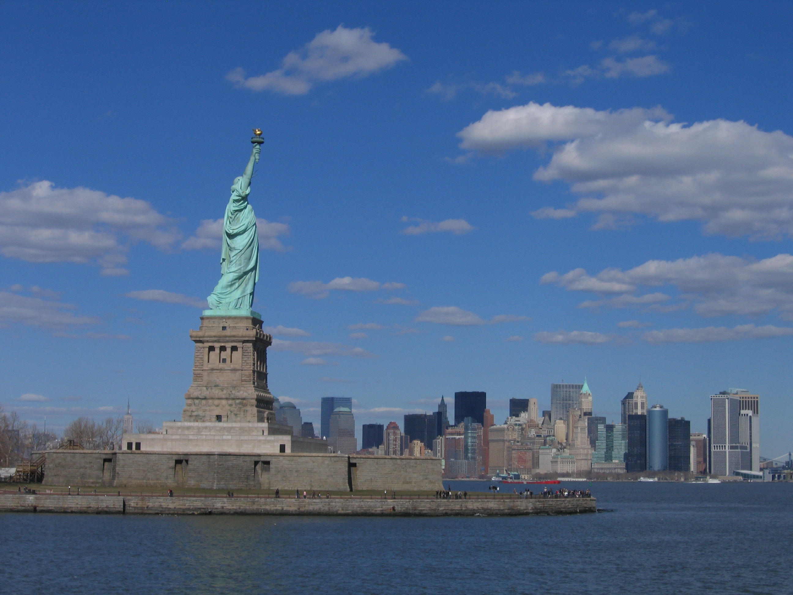
Statue of Liberty stands tall on Liberty Island with the skyline of bustling New York City in view.

Credit: NPS Photo

Close-up of the Statue of Liberty's head, crown, and the folds of her robe

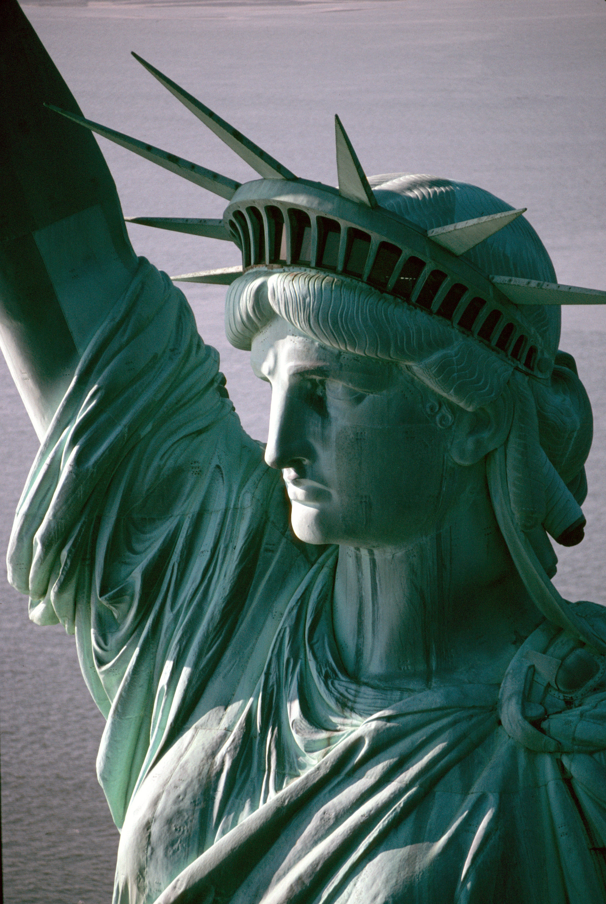
This close-up reveals fine details of the Statue of Liberty's face, hair, crown, and robe, which can be difficult to see even in person.

Credit: NPS Photo

Entire patina green Statue of Liberty and very top of granite pedestal

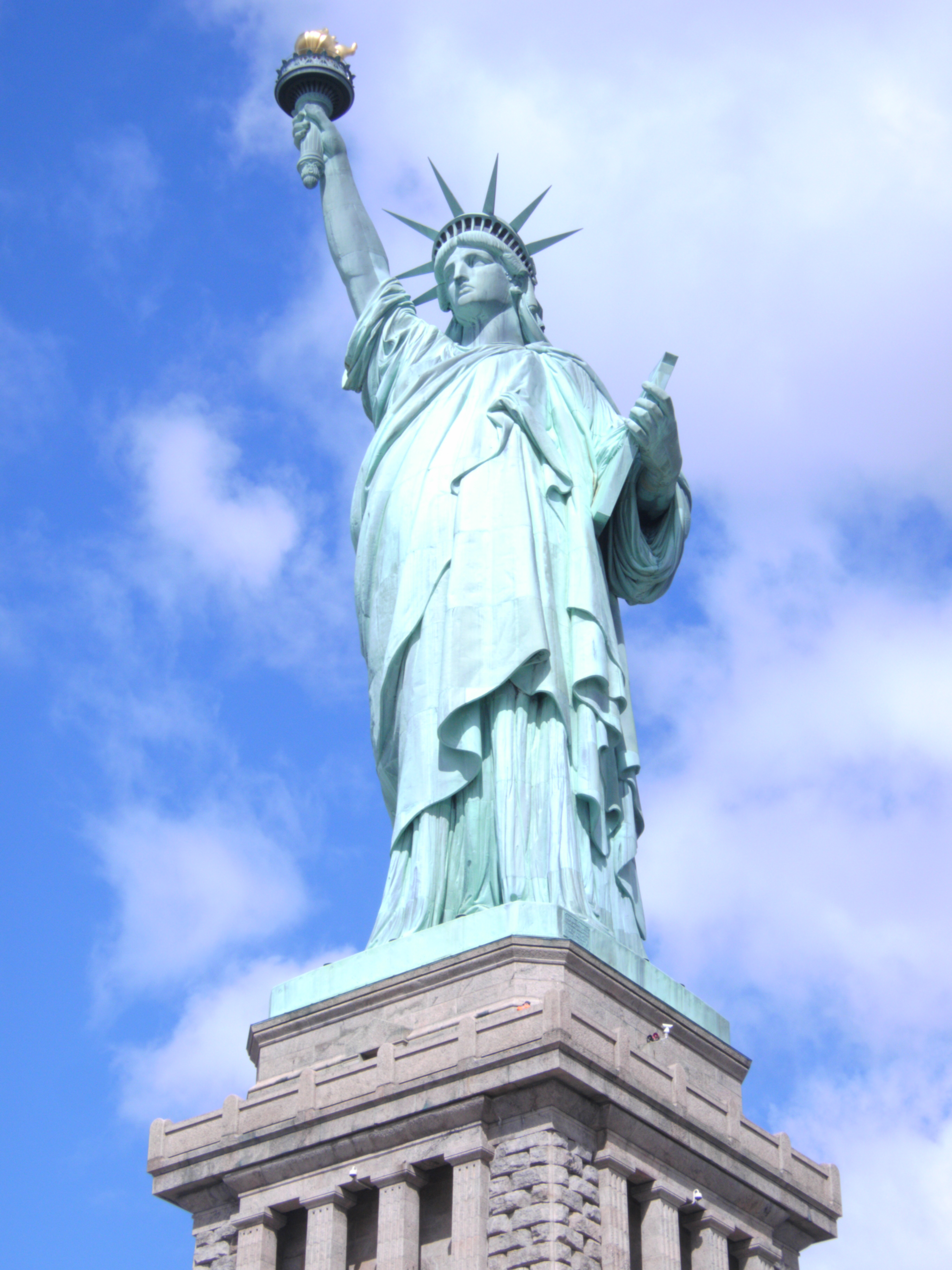
The Statue of Liberty stands tall on her pedestal: from the ground to the tip of the torch, she measures 305 feet 1 inch (93 meters)!

Credit: NPS Photo

Shoulders, head, and raised right arm of the Statue of Liberty from behind the statue.

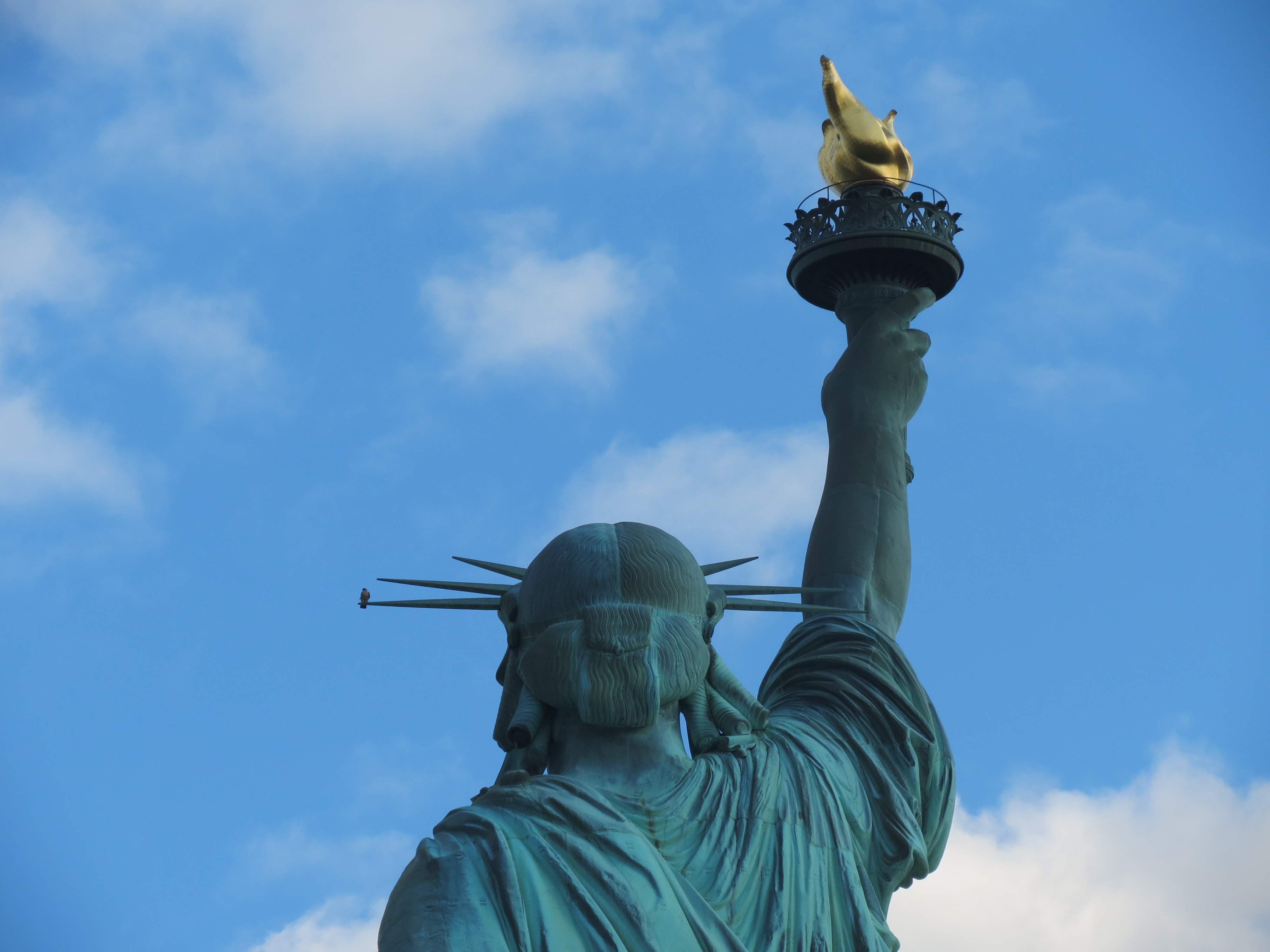
Millions visit the Statue of Liberty each year, but only a select few, like this peregrine falcon perched on the left-most ray, enjoy the view from above the crown.

Credit: NPS Photo

Activities

Topics

Operating Hours

Sunday
9:00AM - 6:30PM
Monday
9:00AM - 6:30PM
Tuesday
9:00AM - 6:30PM
Wednesday
9:00AM - 6:30PM
Thursday
9:00AM - 6:30PM
Friday
9:00AM - 6:30PM
Saturday
9:00AM - 6:30PM

Entrance Fees

No entrance fees listed.

Entrance Passes

No entrance passes listed.

3-Day Weather Forecast

Saturday, Feb 21

Overcast

Overcast

High: 45.9°F | Low: 34.9°F

Humidity: 84%

Wind: 10.3 mph

Rain Chance: 0%

UV Index: 0.6

Sunrise: 06:41 AM

Sunset: 05:38 PM

Moon: Waxing Crescent (14%)

Visibility: 6 mi

Dew Point: 37.1°F

Cloud Cover: 0%

Pressure: N/A mb

Air Quality (PM2.5): N/A

Ozone: N/A

EPA Index: N/A

Sunday, Feb 22

Heavy rain

Heavy rain

High: 36.5°F | Low: 31.5°F

Humidity: 96%

Wind: 27.7 mph

Rain Chance: 74%

UV Index: 0.2

Sunrise: 06:40 AM

Sunset: 05:40 PM

Moon: Waxing Crescent (23%)

Visibility: 1 mi

Dew Point: 33.7°F

Cloud Cover: 74%

Pressure: N/A mb

Air Quality (PM2.5): N/A

Ozone: N/A

EPA Index: N/A

Monday, Feb 23

Blizzard

Blizzard

High: 30.7°F | Low: 27.7°F

Humidity: 90%

Wind: 28.4 mph

Rain Chance: 88%

UV Index: 0.3

Sunrise: 06:39 AM

Sunset: 05:41 PM

Moon: Waxing Crescent (33%)

Visibility: 1 mi

Dew Point: 27.1°F

Cloud Cover: 88%

Pressure: N/A mb

Air Quality (PM2.5): N/A

Ozone: N/A

EPA Index: N/A

Weather Alerts (5)

⚠️ Winter Storm Warning (Severe)

Winter Storm Warning issued February 21 at 2:44AM EST until February 23 at 6:00PM EST by NWS Upton NY

Effective: Feb 21, 2026 2:44am
Expires: Feb 21, 2026 2:00pm

* WHAT...Heavy snow expected. Total snow accumulations between 11
and 15 inches. Winds gusting as high as 45 mph.

* WHERE...Portions of southern Connecticut, northeast New Jersey,
and southeast New York.

* WHEN...From 6 AM Sunday to 6 PM EST Monday.

* IMPACTS...The strong winds and weight of snow on tree limbs may
down power lines and could cause sporadic power outages. Travel
could be very difficult to impossible. Areas of blowing snow could
significantly reduce visibility. The hazardous conditions could
impact the Monday morning and evening commutes.

* ADDITIONAL DETAILS...Strongest winds are expected Sunday night
into Monday. However, snow will move in during the morning and
afternoon hours.

⚠️ Blizzard Warning (Extreme)

Blizzard Warning issued February 21 at 1:02PM EST until February 23 at 6:00PM EST by NWS Upton NY

Effective: Feb 21, 2026 1:02pm
Expires: Feb 22, 2026 3:00am

* WHAT...Blizzard conditions expected. Total snow accumulations
between 12 and 18 inches, highest towards the NYC metro. Winds
gusting as high as 50 mph.

* WHERE...Northeast New Jersey.

* WHEN...From 1 PM Sunday to 6 PM EST Monday.

* IMPACTS...Visibilities may drop below 1/4 mile due to falling and
blowing snow. Whiteout conditions are expected and will make
travel treacherous and potentially life-threatening. The strong
winds and weight of snow on tree limbs may down power lines and
could cause sporadic power outages. Travel could be very difficult
to impossible. Areas of blowing snow could significantly reduce
visibility. The hazardous conditions will impact the Monday
morning and evening commutes.

* ADDITIONAL DETAILS...Strongest winds are expected Sunday evening
through Monday afternoon.

⚠️ Blizzard Warning (Extreme)

Blizzard Warning issued February 21 at 2:44AM EST until February 23 at 6:00PM EST by NWS Upton NY

Effective: Feb 21, 2026 2:44am
Expires: Feb 21, 2026 2:00pm

* WHAT...Blizzard conditions expected. Total snow accumulations
between 13 and 18 inches. Winds gusting as high as 55 mph.

* WHERE...Portions of southern Connecticut and southeast New York.

* WHEN...From 6 AM Sunday to 6 PM EST Monday.

* IMPACTS...Visibilities may drop below 1/4 mile due to falling and
blowing snow. Whiteout conditions are expected and will make
travel treacherous and potentially life-threatening. The strong
winds and weight of snow on tree limbs may down power lines and
could cause sporadic power outages. The hazardous conditions could
impact the Monday morning and evening commutes. Strong winds could
cause tree damage.

* ADDITIONAL DETAILS...Strongest winds and blizzard conditions are
expected to Sunday night into Monday. However, snow will move in
during the morning and afternoon hours.

⚠️ Blizzard Warning (Extreme)

Blizzard Warning issued February 21 at 1:02PM EST until February 23 at 6:00PM EST by NWS Upton NY

Effective: Feb 21, 2026 1:02pm
Expires: Feb 22, 2026 3:00am

* WHAT...Blizzard conditions expected. Total snow accumulations
between 15 and 20 inches, highest amounts across Long Island.
Winds gusting as high as 55 mph with isolated gusts up to 60 mph.
Gusts on the east end of Long Island could reach 65 mph.

* WHERE...Portions of southern Connecticut and southeast New York.

* WHEN...From 1 PM Sunday to 6 PM EST Monday.

* IMPACTS...Visibilities may drop below 1/4 mile due to falling and
blowing snow. Whiteout conditions are expected and will make
travel treacherous and potentially life-threatening. The strong
winds and weight of snow on tree limbs may down power lines and
could cause sporadic power outages. Travel could be very difficult
to impossible. Areas of blowing snow could significantly reduce
visibility. The hazardous conditions will impact the Monday
morning and evening commutes.

* ADDITIONAL DETAILS...Strongest winds are expected Sunday evening
through Monday afternoon.

⚠️ Coastal Flood Watch (Moderate)

Coastal Flood Watch issued February 20 at 4:27PM EST until February 23 at 5:00AM EST by NWS Upton NY

Effective: Feb 20, 2026 4:27pm
Expires: Feb 21, 2026 5:00pm

* WHAT...1 1/2 to 2 1/2 ft of inundation above ground level
possible in vulnerable areas near the waterfront and shoreline.

* WHERE...Bronx, Northwest Suffolk, Northern Queens and Northern
Nassau Counties.

* WHEN...Late Sunday night.

* COASTAL FLOOD IMPACTS...Widespread moderate flooding of
vulnerable areas near the waterfront and shoreline possible. 1
1/2 to 2 1/2 ft of inundation above ground level possible in low
lying, vulnerable areas. This would result in numerous road
closures and cause widespread flooding of low lying property
including parking lots, parks, lawns and homes/businesses with
basements near the waterfront. Vehicles parked in vulnerable
areas near the waterfront will likely become flooded. Flooding
will also extend inland from the waterfront along tidal rivers
and bays. Ice cover in the bays and harbors could
exacerbate flooding and cause damage to northeast to east facing
shoreline structure.

* SHORELINE IMPACTS...Breaking surf of 3 to 5 ft along north and
east facing shorelines will cause beach flooding and dune
erosion during the time of high tide. This may also exacerbate
splashover flooding of shorelines roads and properties behind
protective dunes, structures and seawalls. Minor damage to
shoreline structures possible.

* ADDITIONAL DETAILS...This water level forecast will be highly
dependent on timing of windshift from east northeast to north
gales with respect to the time of high tide, and will be refined
over the next 24 hours. Ice cover in the bays and harbors could
exacerbate flooding and cause damage to northeast to east facing
shoreline structure.

Park Alerts

Early Park Closure-Thursday Aug 21, 2025 Park Closure
Due to Hurricane Erin offshore with high tide at 7:47PM and high winds, the last visitor boats will depart from the Battery and Liberty State Park to the islands at 3:30PM. Last public boats back to the mainland are at 5:00PM (Liberty) and 5:15PM (Ellis).
Delayed Opening - Saturday, December 27 - First Ferry 10:50 AM Park Closure
Due to a predicted winter storm, Statue of Liberty National Monument and Ellis Island will have a delayed opening on Saturday, December 27. The first ferry departs at 10:50 AM from The Battery (NY) and Liberty State Park (NJ).
Winter Storm Closure - January 25 & January 26 Park Closure
The park will be closed on Sunday, January 25, and Monday, January 26. The National Weather Service has issued a Winter Storm Warning for NYC with a forecast of heavy snow and hazardous weather. Please visit statuecitycruises.com for refund and ticketing information.
Ellis Island National Museum of Immigration Information
Due to a mechanical issue, there will be NO elevator service on Ellis Island until further notice. Here are some of the exhibits you can explore while on the first floor of the museum.

More Info

Visitor Center & Contacts

📍 Physical Address:
Liberty Island
New York, NY 10004

🏤 Mailing Address:
Receiving Office
1 Ellis Island
Jersey City, NJ 07305

📞 Voice Phone: 2123633200

✉️ Email: stli_info@nps.gov

Park Location


👏 Fun Fact
Loading fun fact...