Wind Cave National Park
Designation: National Park
Location: South Dakota
📘 Park Overview
Wind Cave National Park protects two very different worlds - one deep within the earth, the other a sunlit world of many resources. Bison, elk, and other wildlife roam the rolling prairie grasslands and forested hillsides of one of America's oldest national parks. Below the remnant island of intact prairie sits Wind Cave, one of the longest and most complex caves in the world.
🌤 Weather Information
Spring: Highs range from 50-70°F with highly variable weather. Spring is the park's wettest season. Summer: Hot and generally dry with daytime temperatures regularly exceeding 80°F (27°C). Strong thunderstorms are common and can produce large hail and lightning. Fall: Generally dry with warm days and cool nights. Highs 50-60°F. Lows below freezing are common. Winter: Highs are in the high 30s with lows around 10°F. Snowfall averages 30 inches annually, periodically closing park roads.
🚗 Directions
Wind Cave National Park is located in South Dakota about 11 miles north of Hot Springs, or about 22 miles south of Custer, on US Highway 385. The park Visitor Center, where all cave tours begin, is approximately 1/2 mile west of the highway.
Images
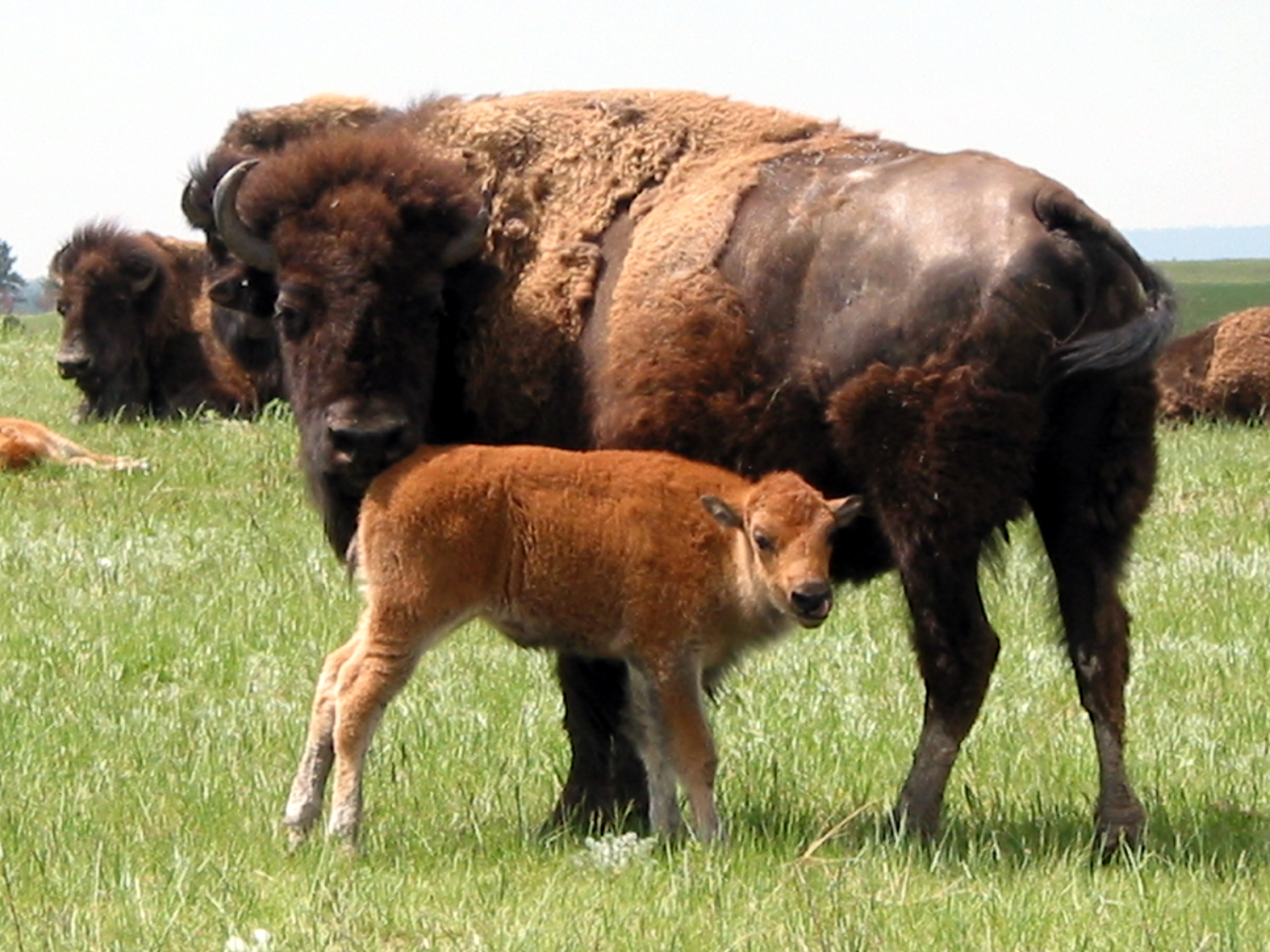
Several hundred bison roam the rolling prairie of Wind Cave National Park.
Credit: NPS Photo / Dan Roddy
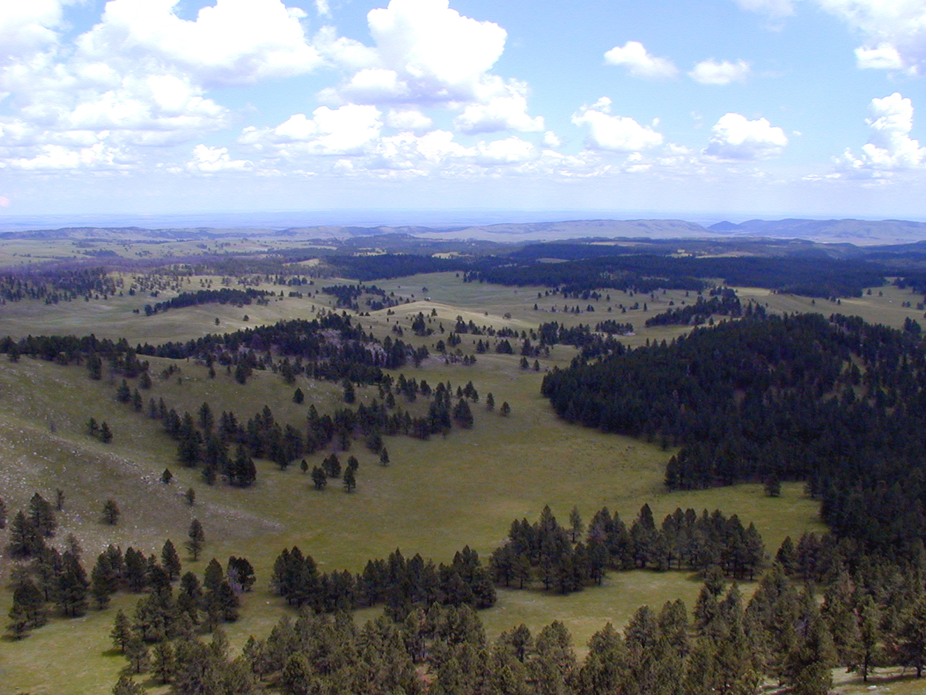
Wind Cave National Park from Rankin Ridge, the park's highest point.
Credit: NPS Photo
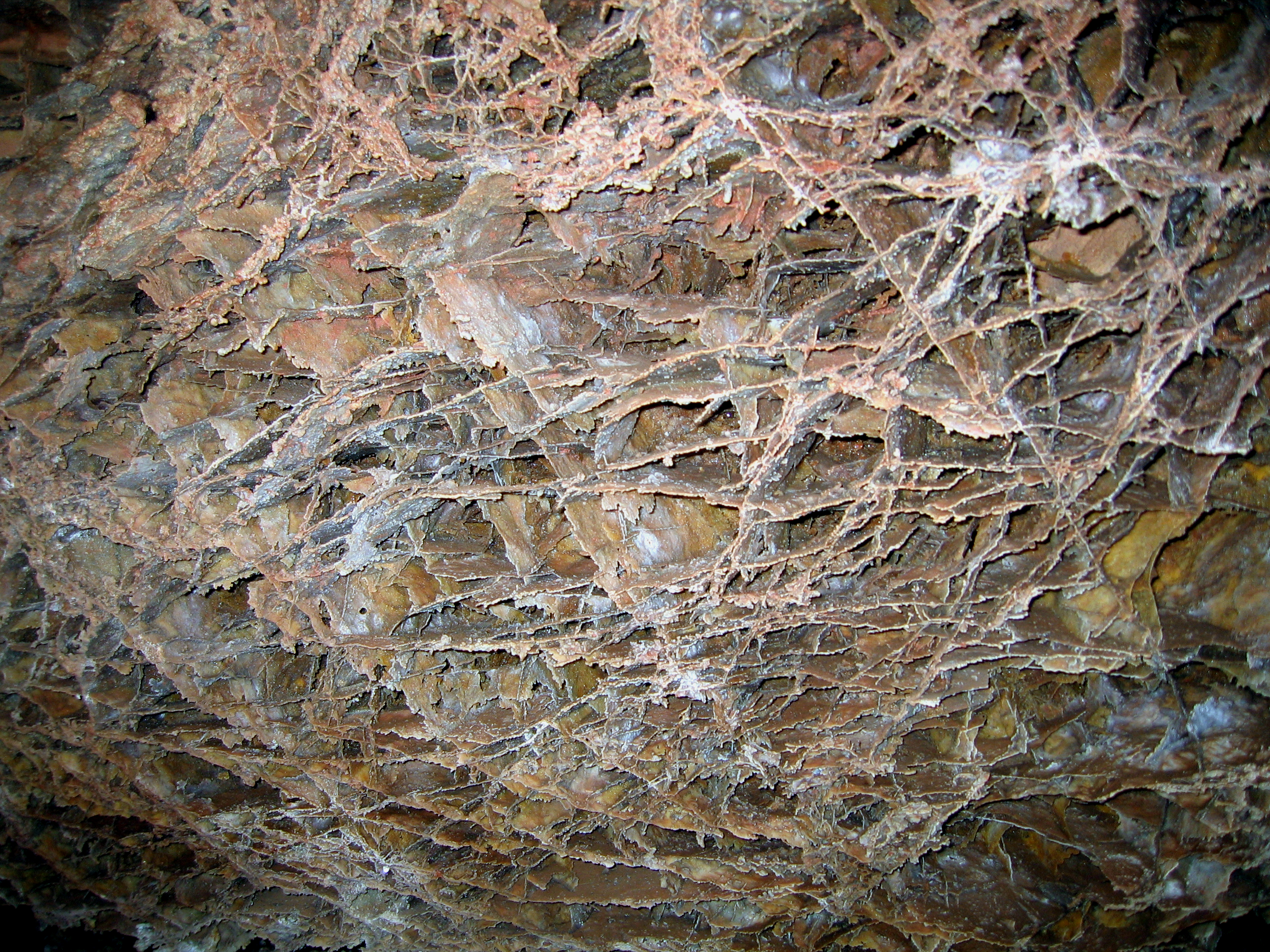
Delicate fins of boxwork, a rare cave feature, in Elk's Room, Wind Cave.
Credit: NPS Photo

Each summer, the Wild Cave Tour offers the chance to get up close and personal with Wind Cave.
Credit: NPS Photo
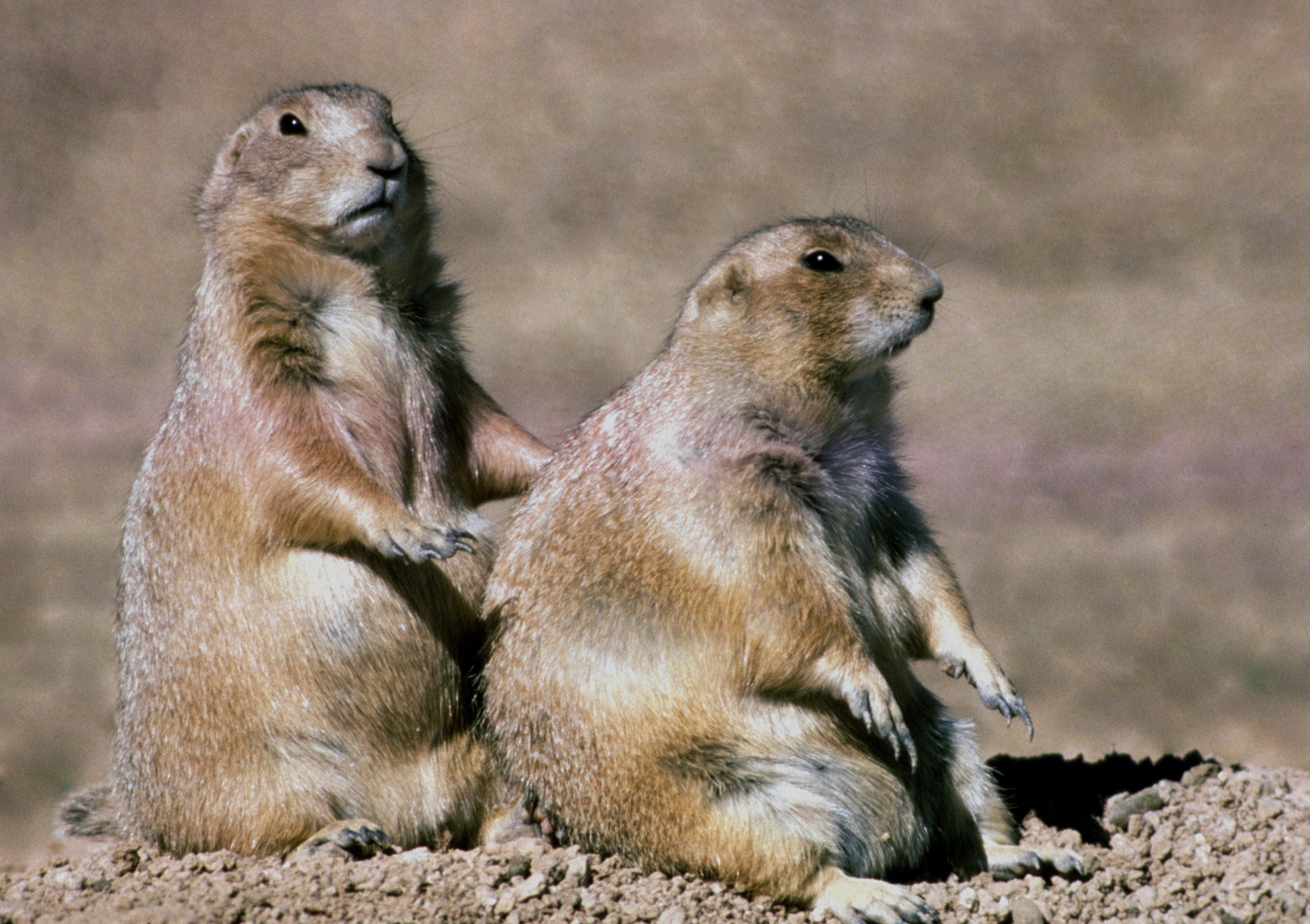
Prairie dog sightings are common throughout the park's prairies.
Credit: NPS Photo
Activities
Topics
Operating Hours
Entrance Fees
No entrance fees listed.
Entrance Passes
No entrance passes listed.
3-Day Weather Forecast
Wednesday, Apr 22

Partly Cloudy
High: 75.7°F | Low: 52.1°F
Humidity: 21%
Wind: 19.9 mph
Rain Chance: 0%
UV Index: 7.5
Sunrise: 06:00 AM
Sunset: 07:47 PM
Moon: Waxing Crescent (27%)
Visibility: 6 mi
Dew Point: 49.2°F
Cloud Cover: 0%
Pressure: N/A mb
Air Quality (PM2.5): N/A
Ozone: N/A
EPA Index: N/A
Thursday, Apr 23

Moderate rain
High: 50.5°F | Low: 31.3°F
Humidity: 61%
Wind: 24.8 mph
Rain Chance: 85%
UV Index: 5.5
Sunrise: 05:58 AM
Sunset: 07:48 PM
Moon: Waxing Crescent (38%)
Visibility: 5 mi
Dew Point: 34.2°F
Cloud Cover: 85%
Pressure: N/A mb
Air Quality (PM2.5): N/A
Ozone: N/A
EPA Index: N/A
Friday, Apr 24

Light freezing rain
High: 39.6°F | Low: 24.7°F
Humidity: 56%
Wind: 17.2 mph
Rain Chance: 82%
UV Index: 5.6
Sunrise: 05:57 AM
Sunset: 07:49 PM
Moon: First Quarter (49%)
Visibility: 6 mi
Dew Point: 23.2°F
Cloud Cover: 82%
Pressure: N/A mb
Air Quality (PM2.5): N/A
Ozone: N/A
EPA Index: N/A
Weather Alerts (2)
Red Flag Warning issued April 21 at 12:48PM MDT until April 22 at 8:00PM MDT by NWS Rapid City SD
Effective: Apr 21, 2026 2:48pm
Expires: Apr 22, 2026 8:00am
...RED FLAG WARNING IN EFFECT LATE WEDNESDAY MORNING THROUGH
EARLY EVENING ACROSS NORTHEASTERN WYOMING AND WESTERN SOUTH
DAKOTA...
.Hot, dry, and windy conditions will support widespread critical
fire weather conditions Wednesday, mainly in the afternoon and
evening. Temperatures tomorrow will range from the 80s to mid 90s
with minimum humidities dropping to as low as 10%. Meanwhile,
southwesterly winds will increase through the morning as a cold
front approaches the region. Sustained winds will be at 20 to 30
mph with gusts of 35 to 45 mph. Scattered thunderstorms are
possible across western to central South Dakota Wednesday
afternoon and evening. These storms may contain cloud-to-ground
lightning and erratic winds with gusts in excess of 50 mph while
producing very little precip. This could lead to fire initiation.
Conditions will improve Wednesday evening as temperatures fall,
humidity rises, and a cold front quickly crosses the area.
The National Weather Service in Rapid City has issued a Red Flag
Warning for gusty winds and low relative humidity, which is in
effect from 10 AM MDT /11 AM CDT/ to 8 PM MDT /9 PM CDT/
Wednesday. The Fire Weather Watch is no longer in effect.
* AFFECTED AREA...Fire Weather Zones 314 Northern Campbell, 315
Southern Campbell, 316 Crook County Plains, 317 Weston County
Plains, 318 Wyoming Black Hills, 319 Northern Black Hills, 320
Central Black Hills, 321 Southern Black Hills, 322 Fall River
County Area, 323 Northern Foot Hills, 324 Eastern Foot Hills,
325 Custer County Plains, 326 Pine Ridge Area, 327 Butte
County Area, 329 West Central Plains, 330 Ziebach County, 331
Haakon County Area, 332 Badlands Area, 333 Bennett County
Area, 334 Mellette and Todd Counties and 335 Tripp County.
* WINDS...Southwest 20 to 30 mph with gusts up to 45 mph.
* RELATIVE HUMIDITY...As low as 10 percent.
* IMPACTS...The combination of gusty winds and low relative
humidity would produce critical fire weather conditions.
Red Flag Warning issued April 21 at 9:36PM MDT until April 22 at 8:00PM MDT by NWS Rapid City SD
Effective: Apr 21, 2026 11:36pm
Expires: Apr 22, 2026 2:45pm
...RED FLAG WARNING IN EFFECT LATE WEDNESDAY MORNING THROUGH
EARLY EVENING ACROSS NORTHEASTERN WYOMING AND WESTERN SOUTH
DAKOTA...
.Hot, dry, and windy conditions will support widespread critical
fire weather conditions Wednesday, mainly in the afternoon and
evening. Temperatures tomorrow will range from the 80s to mid 90s
with minimum humidities dropping to as low as 9%. Meanwhile,
southwesterly winds will increase through the morning as a cold
front approaches the region. Sustained winds will be at 20 to 30
mph with gusts of 35 to 45 mph. Scattered thunderstorms are
possible across western to central South Dakota Wednesday
afternoon and evening. These storms may contain cloud-to-ground
lightning and erratic winds with gusts in excess of 50 mph while
producing very little precip. This could lead to fire initiation.
Conditions will improve Wednesday evening as temperatures fall,
humidity rises, and a cold front quickly crosses the area.
* AFFECTED AREA...Fire Weather Zones 314 Northern Campbell, 315
Southern Campbell, 316 Crook County Plains, 317 Weston County
Plains, 318 Wyoming Black Hills, 319 Northern Black Hills, 320
Central Black Hills, 321 Southern Black Hills, 322 Fall River
County Area, 323 Northern Foot Hills, 324 Eastern Foot Hills,
325 Custer County Plains, 326 Pine Ridge Area, 327 Butte
County Area, 328 Perkins County, 329 West Central Plains, 330
Ziebach County, 331 Haakon County Area, 332 Badlands Area, 333
Bennett County Area, 334 Mellette and Todd Counties and 335
Tripp County.
* WINDS...Southwest 20 to 30 mph with gusts up to 45 mph.
* RELATIVE HUMIDITY...As low as 9 percent.
* IMPACTS...The combination of gusty winds and low relative
humidity would produce critical fire weather conditions.
Park Alerts
Visitor Center & Contacts
📍 Physical Address:
26611 US Highway 385
Hot Springs, SD 57747
🏤 Mailing Address:
26611 US Highway 385
Hot Springs, SD 57747
📞 Voice Phone: 6057454600
📞 Fax Phone: 6057454207
✉️ Email: WICA_interpretation@nps.gov