Wing Luke Museum Affiliated Area
Designation: Affiliated Area
Location: Washington
📘 Park Overview
More than a museum, the Wing is an experience. A chance to truly understand what it was - and is - to be Asian American in the Pacific Northwest. Take a guided tour of a historic hotel and learn the inside story about what makes the local Chinatown-International District unique. Visitors explore thought-provoking exhibitions of real stories, including actor and martial arts master Bruce Lee.
🌤 Weather Information
Seattle has a temperate climate with average winter temperatures in the 50s and average summer temperatures in the 70s. Overcast skies and light rain are common from October through May.
🚗 Directions
The Wing Luke Museum is located in Seattle’s Chinatown-International District at 719 South King Street (between 7th and 8th Avenue South). It is accessible by foot, public transportation, and car.
Images
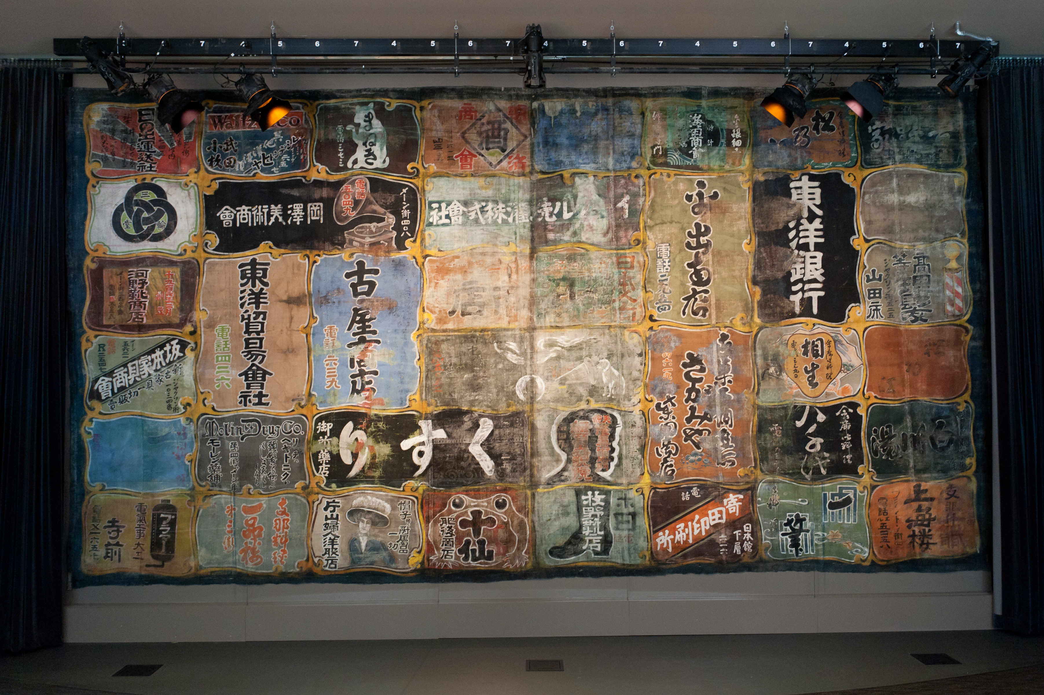
Nippon Kan Theatre curtain, painted with logos and ads for local Japanese-American businesses
Credit: Lindsay Kennedy
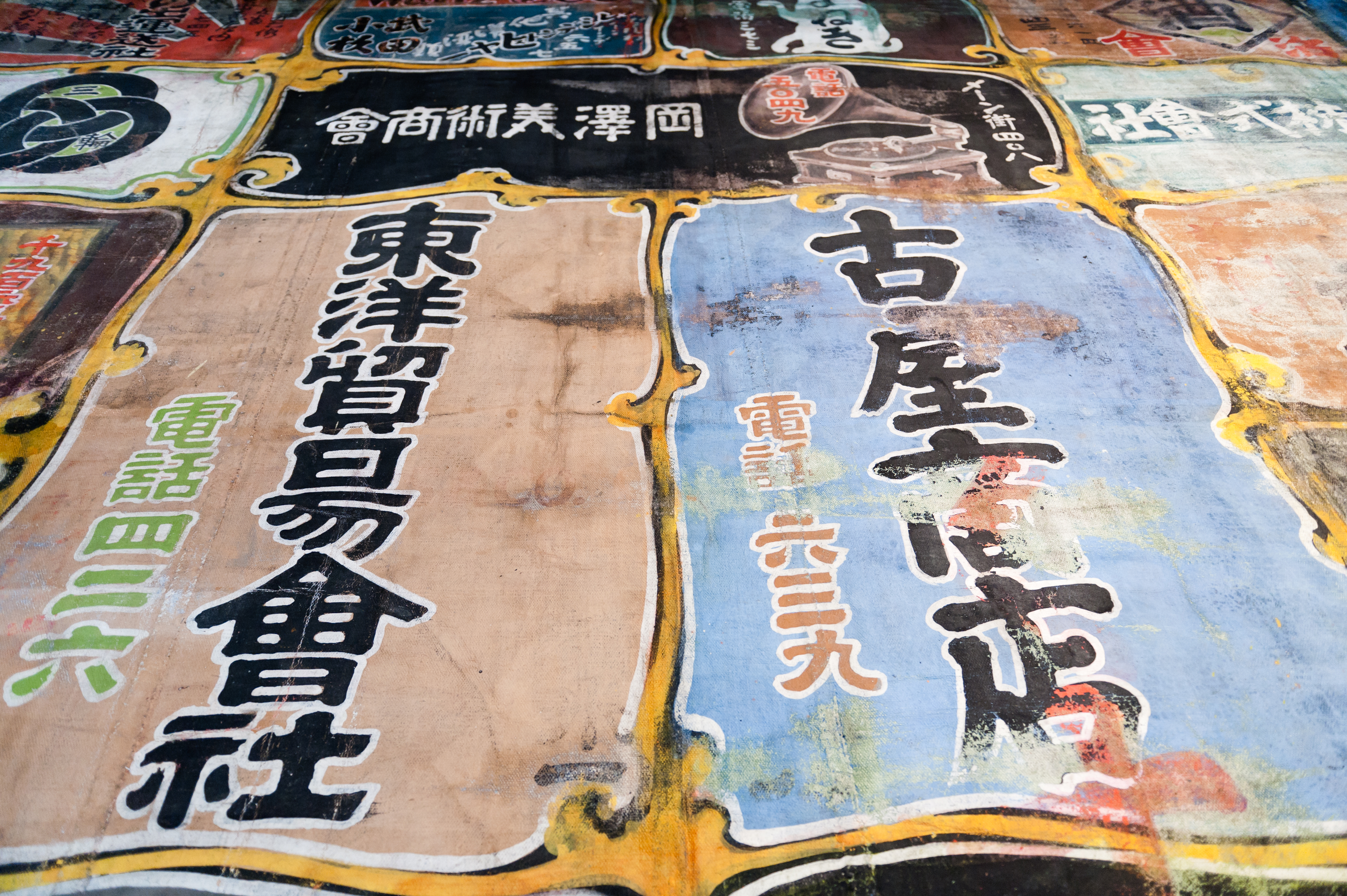
Detail of advertisements from the Nippon Kan Theatre curtain that hangs in the museum
Credit: Lindsay Kennedy
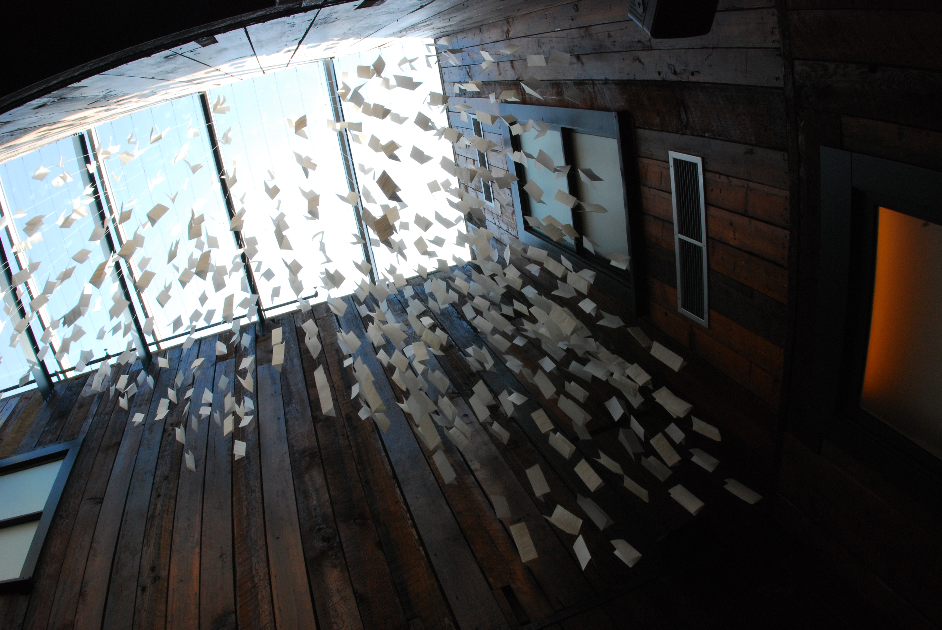
“Letter Cloud,” by Erin Shie Palmer, is made up of letters written by immigrants to family and friends
Credit: Dean Wong
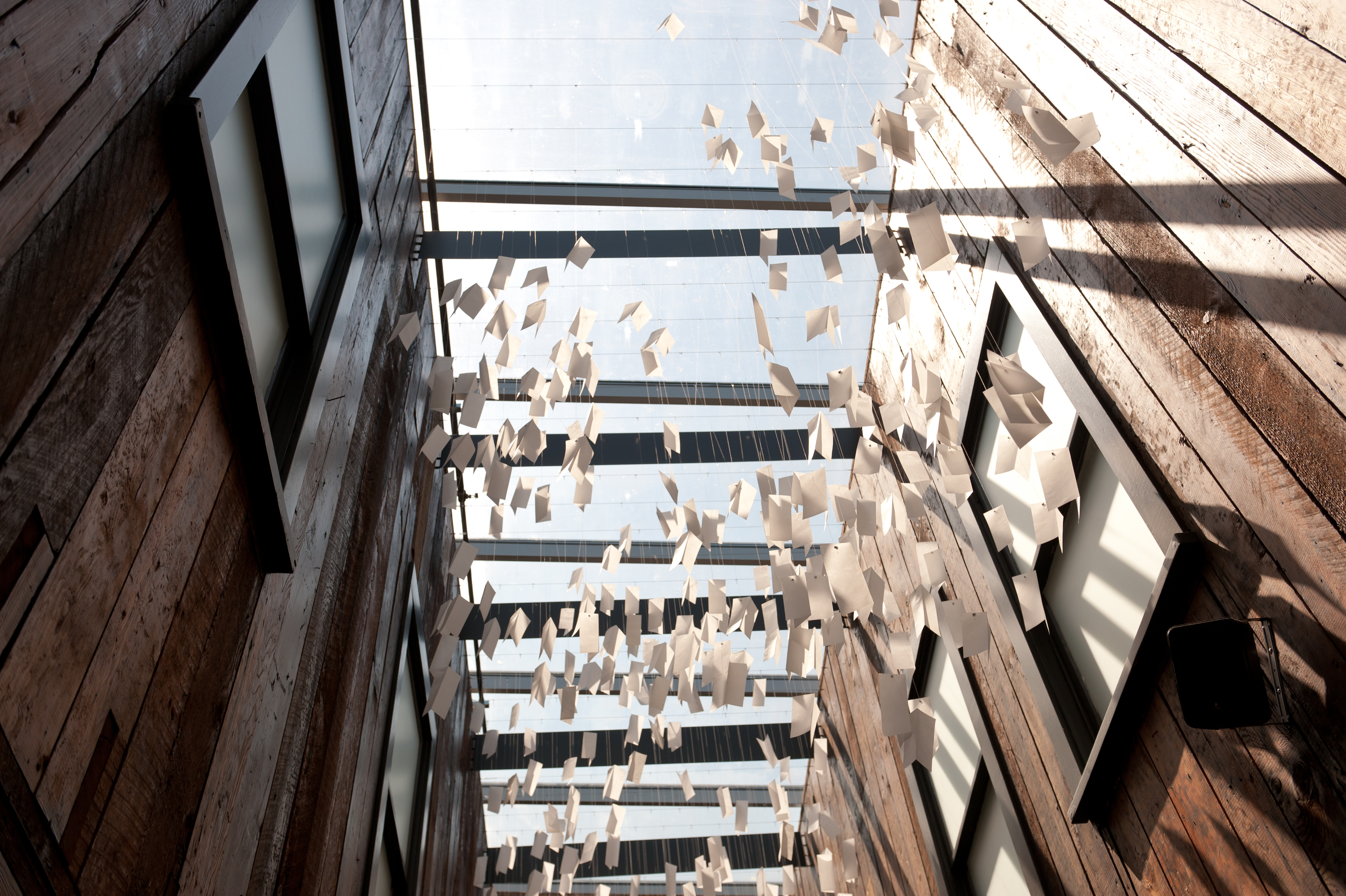
“Letter Cloud,” by Erin Shie Palmer, is made up of letters written by immigrants to family and friends
Credit: Lindsay Kennedy
Activities
Topics
Operating Hours
Entrance Fees
No entrance fees listed.
Entrance Passes
No entrance passes listed.
3-Day Weather Forecast
Friday, Mar 20

Moderate rain
High: 59°F | Low: 46.2°F
Humidity: 90%
Wind: 13 mph
Rain Chance: 87%
UV Index: 0.2
Sunrise: 07:12 AM
Sunset: 07:23 PM
Moon: Waxing Crescent (1%)
Visibility: 3 mi
Dew Point: 50.5°F
Cloud Cover: 87%
Pressure: N/A mb
Air Quality (PM2.5): N/A
Ozone: N/A
EPA Index: N/A
Saturday, Mar 21

Overcast
High: 43.5°F | Low: 38.5°F
Humidity: 80%
Wind: 6.9 mph
Rain Chance: 0%
UV Index: 0.3
Sunrise: 07:10 AM
Sunset: 07:24 PM
Moon: Waxing Crescent (5%)
Visibility: 5 mi
Dew Point: 37.5°F
Cloud Cover: 0%
Pressure: N/A mb
Air Quality (PM2.5): N/A
Ozone: N/A
EPA Index: N/A
Sunday, Mar 22

Partly Cloudy
High: 51.4°F | Low: 37°F
Humidity: 70%
Wind: 7.8 mph
Rain Chance: 0%
UV Index: 0.7
Sunrise: 07:08 AM
Sunset: 07:26 PM
Moon: Waxing Crescent (11%)
Visibility: 6 mi
Dew Point: 37.6°F
Cloud Cover: 0%
Pressure: N/A mb
Air Quality (PM2.5): N/A
Ozone: N/A
EPA Index: N/A
Weather Alerts (5)
Special Weather Statement issued March 19 at 12:11PM PDT by NWS Seattle WA
Effective: Mar 19, 2026 3:11pm
Expires: Mar 20, 2026 3:15pm
Rainfall of 2 to 7 inches over the past 3 days has increased soil
moisture to high levels across western Washington. Heavy rainfall of
0.75 up to 4 inches is expected over the next 30 hours. This amount
of rain will put extra pressure on soil instability, leading to an
increased threat of landslides and debris flows, especially from
recent burned areas.
Over the last couple days at least one landslide has been reported
in King County. More landslides are possible.
Areas most susceptible to landslides debris flows under these
conditions are steep coastal bluffs, other steep hillsides or
road cuts, and recent burned areas. A diminishing threat of
landslides and debris flows will continue for several days after
the rain ends.
For more information about current conditions, visit
www.weather.gov/seattle, select Hydrology, and then scroll down
for the links to the landslide information pages.
For more information on landslides, visit the website for the
Washington State Department of Natural Resources landslide
geologic hazards at: http://bit.ly/2mtA3wn
Flood Watch issued March 20 at 5:17AM PDT until March 20 at 5:00PM PDT by NWS Seattle WA
Effective: Mar 20, 2026 8:17am
Expires: Mar 20, 2026 8:00pm
* WHAT...Flooding caused by excessive rainfall continues to be
possible.
* WHERE...Portions of northwest and west central Washington,
including the following counties, in northwest Washington, Skagit
and Whatcom. In west central Washington, King and Snohomish.
* WHEN...Until 5 PM PDT this afternoon.
* IMPACTS...Excessive runoff may result in flooding of rivers,
creeks, streams, and other low-lying and flood-prone locations.
* ADDITIONAL DETAILS...
- An additional 1 to 1.5 inches of rain are expected over the
North and Central Cascades today.
- http://www.weather.gov/safety/flood
Flood Warning issued March 20 at 2:51AM PDT until March 21 at 4:13AM PDT by NWS Seattle WA
Effective: Mar 20, 2026 5:51am
Expires: Mar 20, 2026 2:00pm
...The National Weather Service in Seattle WA has issued a Flood
Warning for the following rivers in Washington...
Tolt River Above Carnation affecting King County.
.Additional rain over the Central Cascades will push the Tolt river
above flood stage again this morning.
* WHAT...Minor flooding is forecast.
* WHERE...Tolt River above Carnation.
* WHEN...From early this morning to late tonight.
* IMPACTS...At 5,000.0 cfs, the Tolt River will flood Tolt River Rd
NE and many driveways. Some homes in the San Souci area could be
inaccessible due to deep and quick flood waters. This river level
on the Tolt corresponds to a phase 3 flood in the King County
flood system.
* ADDITIONAL DETAILS...
- At 1:15 AM PDT Friday the flow was 4,850 cfs.
- Flood flow is 5,000 cfs.
- Forecast...The river is expected to rise to a crest near 5700
cfs late this morning. It will then fall below flood stage
this evening.
- http://www.weather.gov/safety/flood
Flood Warning issued March 20 at 2:33AM PDT until March 22 at 3:17AM PDT by NWS Seattle WA
Effective: Mar 20, 2026 5:33am
Expires: Mar 20, 2026 1:45pm
...The Flood Warning is extended for the following rivers in
Washington...
Snoqualmie River Near Carnation affecting King County.
.Rain will continue today with 1 to 1.5 inches in the Central
Cascades. The steady rain will come to an end tonight.
* WHAT...Moderate flooding is occurring and moderate flooding is
forecast.
* WHERE...Snoqualmie River near Carnation.
* WHEN...Until early Sunday morning.
* IMPACTS...At 56.0 feet, the Snoqualmie River will cause widespread
flooding from Fall City downstream through Carnation and Duvall...
inundating much of the farm land and numerous roads.
* ADDITIONAL DETAILS...
- At 1:15 AM PDT Friday the stage was 56.0 feet.
- Flood stage is 54.0 feet.
- Recent Activity...The maximum river stage in the 24 hours
ending at 1:15 AM PDT Friday was 56.6 feet.
- Forecast...The river is expected to rise to a crest of 57.4
feet late this afternoon. It will then fall below flood stage
tomorrow afternoon.
- http://www.weather.gov/safety/flood
Flood Warning issued March 20 at 2:09AM PDT until March 21 at 7:35AM PDT by NWS Seattle WA
Effective: Mar 20, 2026 5:09am
Expires: Mar 20, 2026 1:15pm
...The National Weather Service in Seattle WA has issued a Flood
Warning for the following rivers in Washington...
Snoqualmie River Near Snoqualmie Falls affecting King County.
.Heavy rain combined with high snow levels in the Central Cascades
Thursday night will push the Snoqualmie River near Snoqualmie Falls
above flood stage Friday morning.
* WHAT...Minor flooding is forecast.
* WHERE...Snoqualmie River near Snoqualmie Falls.
* WHEN...Until tomorrow morning.
* IMPACTS...At 20,000.0 cfs, the Snoqualmie River will cause
widespread flooding of pasture lands and roads along the river
from the town of Snoqualmie downstream through Fall City. Roads
that may become flooded include Fall City-Carnation...Tolt Hill...
and Novelty Flats Roads. This river level on the Snoqualmie
corresponds roughly to a phase 3 flood in the King County flood
system.
* ADDITIONAL DETAILS...
- At 1:00 AM PDT Friday the flow was 18,700.0 cfs.
- Flood flow is 20,000.0 cfs.
- Forecast...The river is expected to rise above flood stage
early this morning to a crest of 25,300 cfs late this
morning. It will then fall below flood stage late this
evening.
- http://www.weather.gov/safety/flood
Visitor Center & Contacts
📍 Physical Address:
719 South King Street
Seattle, WA 98104
🏤 Mailing Address:
719 South King Street
Seattle, WA 98104
📞 Voice Phone: 206.623.5124
✉️ Email: visit@wingluke.org