Black Canyon Of The Gunnison National Park
Designation: National Park
Location: Colorado
📘 Park Overview
Big enough to be overwhelming, yet still intimate enough to feel the pulse of time. Come see some of the steepest cliffs, oldest rock, and craggiest spires in North America. Forces of nature and the Gunnison River sculpted this canyon over two million years. The result is a vertical wilderness of rock, water, and sky.
🌤 Weather Information
Today's Weather: http://www.weather.com/weather/today/l/NPBLCA:13:US CLIMATE Weather can vary greatly throughout the day. Summer daytime temperatures range between 55 to 90F (13 to 32C), nights 45 to 60F (7 to 16C). Winter daytime temperatures range between 15 to 40F (-9 to 4C), nights 10 to 20F (-12 to -6C). Afternoon thunderstorms are common during the summer. Snow accumulation varies greatly year to year. Layered clothing appropriate for the season is recommended.
🚗 Directions
South Rim: 7 miles north on CO Highway 347 from the intersection with U.S. Highway 50 east of Montrose. Physical/GPS address is: 9800 Highway 347, Montrose, CO 81401 North Rim: 11 miles southwest of Crawford, Colorado. From CO Highway 92, turn west on Black Canyon Road approximately 3 miles south of Crawford. Follow the road signs to the park.
Images
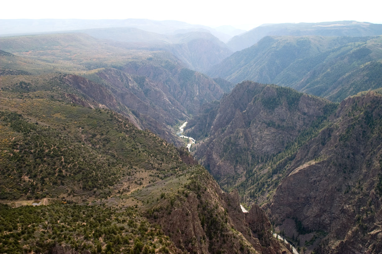
Black Canyon near Tomichi Point
Credit: NPS Photo/Lynch
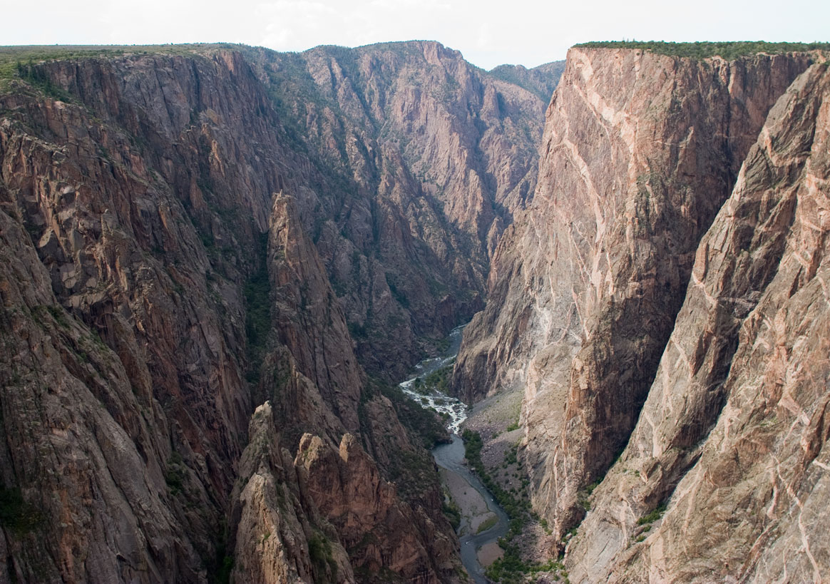
Black Canyon near Painted Wall
Credit: NPS Photo/Lynch
Activities
Topics
Operating Hours
Entrance Fees
Entrance Passes
3-Day Weather Forecast
Thursday, Sep 17

Light rain shower
High: 60.1°F | Low: 54.6°F
Humidity: 88%
Wind: 5.1 mph
Rain Chance: 90%
UV Index: 1.6
Sunrise: 06:54 AM
Sunset: 07:16 PM
Moon: First Quarter (42%)
Visibility: 5 mi
Dew Point: 54.4°F
Cloud Cover: 90%
Pressure: N/A mb
Air Quality (PM2.5): N/A
Ozone: N/A
EPA Index: N/A
Friday, Sep 18

Sunny
High: 77.1°F | Low: 52.1°F
Humidity: 60%
Wind: 18.1 mph
Rain Chance: 36%
UV Index: 4.8
Sunrise: 06:55 AM
Sunset: 07:14 PM
Moon: First Quarter (53%)
Visibility: 6 mi
Dew Point: 54.9°F
Cloud Cover: 36%
Pressure: N/A mb
Air Quality (PM2.5): N/A
Ozone: N/A
EPA Index: N/A
Saturday, Sep 19
Sunny
High: 77.6°F | Low: 52.1°F
Humidity: 52%
Wind: 19.2 mph
Rain Chance: 36%
UV Index: 7.6
Sunrise: 06:56 AM
Sunset: 07:13 PM
Moon: First Quarter (63%)
Visibility: 6 mi
Dew Point: 52.2°F
Cloud Cover: 36%
Pressure: N/A mb
Air Quality (PM2.5): N/A
Ozone: N/A
EPA Index: N/A
Weather Alerts (2)
Flood Advisory issued September 16 at 7:35PM MDT until September 16 at 10:30PM MDT by NWS Grand Junction CO
Effective: Sep 16, 2026 9:35pm
Expires: Sep 17, 2026 12:30am
* WHAT...Urban area and small stream flooding caused by excessive
rainfall is expected.
* WHERE...Northeastern Montrose County in west central Colorado...
* WHEN...Until 1030 PM MDT.
* IMPACTS...Minor flooding in low-lying and poor drainage areas.
Water over roadways.
* ADDITIONAL DETAILS...
- At 734 PM MDT, Doppler radar indicated heavy rain due to
thunderstorms. This will cause urban and small stream flooding.
Between 0.3 and 0.6 inches of rain have fallen. Rainfall rates of
1 to 2 inch an hour are possible.
- Some locations that will experience flooding include...
Montrose.
- http://www.weather.gov/safety/flood
Flood Watch issued September 16 at 9:39AM MDT until September 18 at 12:00AM MDT by NWS Grand Junction CO
Effective: Sep 16, 2026 11:39am
Expires: Sep 17, 2026 8:00am
* WHAT...Flooding caused by excessive rainfall continues to be
possible.
* WHERE...A portion of southwest Colorado, including the following
areas, Animas River Basin, Four Corners/Upper Dolores River,
Northwest San Juan Mountains, San Juan River Basin and Southwest
San Juan Mountains.
* WHEN...Through Thursday evening.
* IMPACTS...Excessive runoff may result in flooding of rivers,
creeks, streams, and other low-lying and flood-prone locations.
This also includes the Gold Mountain, Elk and Ferris burn scars as
well as areas of steep, susceptible terrain.
* ADDITIONAL DETAILS...
- Recent heavy rainfall in southwest Colorado has led to already
saturated ground. In addition, multiple rounds of showers and
thunderstorms are expected Wednesday afternoon through Thursday
evening producing periods of heavy rainfall and potential flash
flooding.
- http://www.weather.gov/safety/flood
Park Alerts
Park Events
Geology Talk
How did the Black Canyon form? What kinds of rocks are these? Discover answers to these and other questions about this dizzying chasm.
Meet at Pulpit Rock Overlook at 10:00 am. 20-30 minutes.
Location subject to change.
May be cancelled due to staffing shortages or bad weather.
Date: Apr 24, 2026 12:00am to Apr 24, 2026 12:00am
Paid Event
Geology Talk
How did the Black Canyon form? What kinds of rocks are these? Discover answers to these and other questions about this dizzying chasm.
Meet at Pulpit Rock Overlook at 10:00 am. 20-30 minutes.
Location subject to change.
May be cancelled due to staffing shortages or bad weather.
Date: Apr 25, 2026 12:00am to Apr 25, 2026 12:00am
Paid Event
Geology Talk
How did the Black Canyon form? What kinds of rocks are these? Discover answers to these and other questions about this dizzying chasm.
Meet at Pulpit Rock Overlook at 10:00 am. 20-30 minutes.
Location subject to change.
May be cancelled due to staffing shortages or bad weather.
Date: Apr 26, 2026 12:00am to Apr 26, 2026 12:00am
Paid Event
Ranger's Choice Talk
Join a park ranger to explore one of the fascinating stories of Black Canyon, from human history to plants to wildlife.
Meet at Pulpit Rock Overlook at 2:00 pm. 20-30 minutes.
Location subject to change.
May be cancelled due to staffing shortages or bad weather.
Date: Jun 9, 2026 12:00am to Sep 30, 2026 12:00am
Paid Event
Visitor Center & Contacts
📍 Physical Address:
South Rim Visitor Center
9800 Highway 347
Montrose, CO 81401
🏤 Mailing Address:
102 Elk Creek
(GPS/physical address = 9800 Highway 347, Montrose, CO)
Gunnison, CO 81230
📞 Voice Phone: 970-641-2337
✉️ Email: blca_info@nps.gov